Heusden geodata
Heusden (North Brabant) is a populated place; located in Netherlands in Europe/Amsterdam (GMT+2) time zone. With population of 1,415 people, there are 1173 cities with bigger population in this country. Compared to other cities in Netherlands, 86.9% of cities are located further ↑North; 55.3% of cities are located further ←West and 85.2% of cities have lower elevation than Heusden. Note1


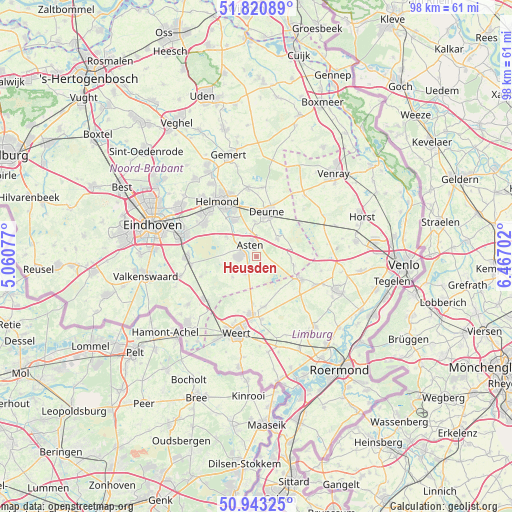
Heusden GPS coordinates[2]
51° 23' 3.012" North, 5° 45' 50.004" East
| Map corner | latitude | longitude |
|---|---|---|
| Upper-left | 51.82089°, | 5.06077° |
| Center: | 51.38417°, | 5.76389° |
| Lower-right: | 50.94325°, | 6.46702° |
| Map W x H: | 97.6×97.6 km | = 60.6×60.6mi |
| max Lat: | 53.48025° ⇑86.9% North |
| Heusden: | 51.38417° |
| min Lat: | ⇓13.1% South 50.76917° |
| min Long | Heusden | max Long |
| 3.38611° | 5.76389° | 7.16528° |
| W 55.3%⇐ | ⇒44.7% E |
Elevation
Elevation of Heusden is 27 m = 89 ft, and this is 12 m = 39 ft above average elevation for this country.
| Max E: |
203 m = 666 ft | 14.8% |
| Heusden | 27 m 89 ft | |
| Avg. | 15 m = 49 ft | |
Min E: |
-6 m = -20 ft | 85.2% |
See also: Netherlands elevation on elevation.city.
Geographical zone
Heusden is located in North temperate zone (between Tropic of Cancer and the Arctic Circle). Distance of this North polar circle is 1687.8 km =1048.7 mi to North.| Distance of | km | miles | from Heusden |
|---|---|---|---|
| North Pole | 4293.7 | 2668 | to North |
| Arctic Circle | 1687.8 | 1048.7 | to North |
| Tropic Cancer | 3107.5 | 1930.9 | to South |
| Equator | 5713.4 | 3550.1 | to South |


Nearby cities:
15 places around Heusden: (largest is in red/bold)
• Asten
2.5 km =1.6 mi,  334°
334°
• Budschop
11 km =6.8 mi,  181°
181°
• Helenaveen
10.6 km =6.6 mi,  86°
86°
• Lierop
7 km =4.3 mi,  303°
303°
• Liessel
5.1 km =3.2 mi,  50°
50°
• Meijel
9.5 km =5.9 mi,  117°
117°
• Nederweert
11 km =6.8 mi,  185°
185°
• Neerkant
7.3 km =4.5 mi,  103°
103°
• Ommel
4.6 km =2.9 mi,  346°
346°
• Ospel
9.7 km =6 mi,  171°
171°
• Someren
3.7 km =2.3 mi,  271°
271°
• Someren-Eind
3.6 km =2.2 mi,  215°
215°
• Vlierden
6.8 km =4.2 mi,  356°
356°
• Walsberg
10.4 km =6.5 mi,  14°
14°
• Zeilberg
8.7 km =5.4 mi,  25°
25°
Sources, notices
• [Note1] Compared only with cities in Netherlands existing in our database
• [Src1] Map data: © OpenStreetMap contributors (CC-BY-SA)
• [Src2] Other city data from geonames.org with taken over terms of usage.
• [Src3] Geographical zone / Annual Mean Temperature by Robert A. Rohde @ Wikipedia
