Asten geodata
Asten (North Brabant) is a populated place; located in Netherlands in Europe/Amsterdam (GMT+2) time zone. With population of 9,535 people, there are 298 cities with bigger population in this country. Compared to other cities in Netherlands, 86.1% of cities are located further ↑North; 54.5% of cities are located further ←West and 85.2% of cities have lower elevation than Asten. Note1


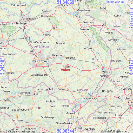
Asten GPS coordinates[2]
51° 24' 15.012" North, 5° 44' 54.996" East
| Map corner | latitude | longitude |
|---|---|---|
| Upper-left | 51.84069°, | 5.04548° |
| Center: | 51.40417°, | 5.74861° |
| Lower-right: | 50.96344°, | 6.45173° |
| Map W x H: | 97.5×97.5 km | = 60.6×60.6mi |
| max Lat: | 53.48025° ⇑86.1% North |
| Asten: | 51.40417° |
| min Lat: | ⇓13.9% South 50.76917° |
| min Long | Asten | max Long |
| 3.38611° | 5.74861° | 7.16528° |
| W 54.5%⇐ | ⇒45.5% E |
Elevation
Elevation of Asten is 27 m = 89 ft, and this is 12 m = 39 ft above average elevation for this country.
| Max E: |
203 m = 666 ft | 14.8% |
| Asten | 27 m 89 ft | |
| Avg. | 15 m = 49 ft | |
Min E: |
-6 m = -20 ft | 85.2% |
See also: Netherlands elevation on elevation.city.
Geographical zone
Asten is located in North temperate zone (between Tropic of Cancer and the Arctic Circle). Distance of this North polar circle is 1685.6 km =1047.4 mi to North.| Distance of | km | miles | from Asten |
|---|---|---|---|
| North Pole | 4291.5 | 2666.6 | to North |
| Arctic Circle | 1685.6 | 1047.4 | to North |
| Tropic Cancer | 3109.7 | 1932.3 | to South |
| Equator | 5715.6 | 3551.5 | to South |


Nearby cities:
15 places around Asten: (largest is in red/bold)
• Brand
10.5 km =6.5 mi,  304°
304°
• Helmond
10.5 km =6.5 mi,  324°
324°
• Heusden
2.5 km =1.6 mi,  154°
154°
• Lierop
5.1 km =3.2 mi,  289°
289°
• Liessel
5.1 km =3.2 mi,  78°
78°
• Mierlo
9.8 km =6.1 mi, 293°
• Milheeze
11 km =6.8 mi,  11°
11°
• Neerkant
9.1 km =5.7 mi,  115°
115°
• Ommel
2.2 km =1.4 mi,  0°
0°
• Schutsboom
10.8 km =6.7 mi,  306°
306°
• Someren
3.4 km =2.1 mi,  230°
230°
• Someren-Eind
5.3 km =3.3 mi,  191°
191°
• Vlierden
4.6 km =2.9 mi, 8°
• Walsberg
8.7 km =5.4 mi,  25°
25°
• Zeilberg
7.4 km =4.6 mi,  40°
40°
Sources, notices
• [Note1] Compared only with cities in Netherlands existing in our database
• [Src1] Map data: © OpenStreetMap contributors (CC-BY-SA)
• [Src2] Other city data from geonames.org with taken over terms of usage.
• [Src3] Geographical zone / Annual Mean Temperature by Robert A. Rohde @ Wikipedia
