Midsland geodata
Midsland (Friesland) is a populated place; located in Netherlands in Europe/Amsterdam (GMT+2) time zone. With population of 915 people, there are 1449 cities with bigger population in this country. Compared to other cities in Netherlands, 99.3% of cities are located further ↓South; 64% of cities are located further →East and 54.1% of cities have higher elevation than Midsland. Note1


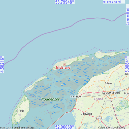
Midsland GPS coordinates[2]
53° 22' 55.74" North, 5° 17' 7.008" East
| Map corner | latitude | longitude |
|---|---|---|
| Upper-left | 53.79948°, | 4.58216° |
| Center: | 53.38215°, | 5.28528° |
| Lower-right: | 52.96069°, | 5.98841° |
| Map W x H: | 93.3×93.3 km | = 58×58mi |
| max Lat: | 53.48025° ⇑0.7% North |
| Midsland: | 53.38215° |
| min Lat: | ⇓99.3% South 50.76917° |
| min Long | Midsland | max Long |
| 3.38611° | 5.28528° | 7.16528° |
| W 36%⇐ | ⇒64% E |
Elevation
Elevation of Midsland is 5 m = 16 ft, and this is 10 m = 33 ft below average elevation for this country.
| Max E: |
203 m = 666 ft | 54.1% |
| Avg. | 15 m = 49 ft | |
| Midsland | 5 m = 16 ft | |
Min E: |
-6 m = -20 ft | 45.9% |
See also: Netherlands elevation on elevation.city.
Geographical zone
Midsland is located in North temperate zone (between Tropic of Cancer and the Arctic Circle). Distance of this North polar circle is 1465.6 km =910.7 mi to North.| Distance of | km | miles | from Midsland |
|---|---|---|---|
| North Pole | 4071.5 | 2529.9 | to North |
| Arctic Circle | 1465.6 | 910.7 | to North |
| Tropic Cancer | 3329.6 | 2068.9 | to South |
| Equator | 5935.5 | 3688.1 | to South |


Nearby cities:
15 places around Midsland: (largest is in red/bold)
• Achlum
29.1 km =18.1 mi,  153°
153°
• Berltsum
28.8 km =17.9 mi,  122°
122°
• Franeker
27.7 km =17.2 mi,  142°
142°
• Harlingen
24.8 km =15.4 mi,  158°
158°
• Hollum
24.2 km =15 mi,  74°
74°
• Midlum
24.8 km =15.4 mi, 154°
• Minnertsga
25.2 km =15.7 mi,  125°
125°
• Oost-Vlieland
16.9 km =10.5 mi,  235°
235°
• Oude Bildtzijl
30.2 km =18.8 mi,  107°
107°
• Sexbierum
22.5 km =14 mi, 144°
• Sint Annaparochie
27.4 km =17 mi, 115°
• Sint Jacobiparochie
24.4 km =15.2 mi, 119°
• Tzummarum
23.7 km =14.7 mi, 132°
• Vrouwenparochie
29.8 km =18.5 mi, 112°
• West-Terschelling
5.3 km =3.3 mi, 241°
Sources, notices
• [Note1] Compared only with cities in Netherlands existing in our database
• [Src1] Map data: © OpenStreetMap contributors (CC-BY-SA)
• [Src2] Other city data from geonames.org with taken over terms of usage.
• [Src3] Geographical zone / Annual Mean Temperature by Robert A. Rohde @ Wikipedia
