West-Terschelling geodata
West-Terschelling (Friesland) is a populated place; located in Netherlands in Europe/Amsterdam (GMT+2) time zone. With population of 2,525 people, there are 833 cities with bigger population in this country. Compared to other cities in Netherlands, 98.7% of cities are located further ↓South; 66.1% of cities are located further →East and 52.4% of cities have lower elevation than West-Terschelling. Note1


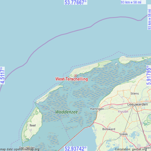
West-Terschelling GPS coordinates[2]
53° 21' 32.796" North, 5° 12' 53.352" East
| Map corner | latitude | longitude |
|---|---|---|
| Upper-left | 53.77667°, | 4.5117° |
| Center: | 53.35911°, | 5.21482° |
| Lower-right: | 52.93742°, | 5.91795° |
| Map W x H: | 93.3×93.3 km | = 58×58mi |
| max Lat: | 53.48025° ⇑1.3% North |
| West-Terschelling: | 53.35911° |
| min Lat: | ⇓98.7% South 50.76917° |
| min Long | West-Terschelli | max Long |
| 3.38611° | 5.21482° | 7.16528° |
| W 33.9%⇐ | ⇒66.1% E |
Elevation
Elevation of West-Terschelling is 7 m = 23 ft, and this is 8 m = 26 ft below average elevation for this country.
| Max E: |
203 m = 666 ft | 47.6% |
| Avg. | 15 m = 49 ft | |
| West-Terschelling | 7 m = 23 ft | |
Min E: |
-6 m = -20 ft | 52.4% |
See also: Netherlands elevation on elevation.city.
Geographical zone
West-Terschelling is located in North temperate zone (between Tropic of Cancer and the Arctic Circle). Distance of this North polar circle is 1468.2 km =912.3 mi to North.| Distance of | km | miles | from West-Terschelling |
|---|---|---|---|
| North Pole | 4074.1 | 2531.5 | to North |
| Arctic Circle | 1468.2 | 912.3 | to North |
| Tropic Cancer | 3327.1 | 2067.4 | to South |
| Equator | 5933 | 3686.6 | to South |


Nearby cities:
15 places around West-Terschelling: (largest is in red/bold)
• Achlum
29.4 km =18.3 mi,  142°
142°
• Arum
30.9 km =19.2 mi,  145°
145°
• Berltsum
31.7 km =19.7 mi,  113°
113°
• Franeker
29 km =18 mi,  131°
131°
• Harlingen
24.7 km =15.3 mi, 146°
• Hollum
29.4 km =18.3 mi,  72°
72°
• Midlum
25.1 km =15.6 mi, 141°
• Midsland
5.3 km =3.3 mi,  61°
61°
• Minnertsga
28 km =17.4 mi,  115°
115°
• Oost-Vlieland
11.6 km =7.2 mi,  233°
233°
• Sexbierum
23.8 km =14.8 mi, 131°
• Sint Annaparochie
30.8 km =19.1 mi, 107°
• Sint Jacobiparochie
27.5 km =17.1 mi, 110°
• Tzum
32.1 km =19.9 mi, 133°
• Tzummarum
25.8 km =16 mi, 121°
Sources, notices
• [Note1] Compared only with cities in Netherlands existing in our database
• [Src1] Map data: © OpenStreetMap contributors (CC-BY-SA)
• [Src2] Other city data from geonames.org with taken over terms of usage.
• [Src3] Geographical zone / Annual Mean Temperature by Robert A. Rohde @ Wikipedia
