Beek geodata
Beek (North Brabant) is a populated place; located in Netherlands in Europe/Amsterdam (GMT+2) time zone. With population of 5,185 people, there are 465 cities with bigger population in this country. Compared to other cities in Netherlands, 78.7% of cities are located further ↑North; 50.8% of cities are located further →East and 72.5% of cities have lower elevation than Beek. Note1


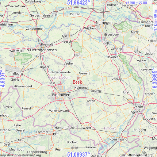
Beek GPS coordinates[2]
51° 31' 44.04" North, 5° 38' 1.752" East
| Map corner | latitude | longitude |
|---|---|---|
| Upper-left | 51.96423°, | 4.9307° |
| Center: | 51.5289°, | 5.63382° |
| Lower-right: | 51.08937°, | 6.33695° |
| Map W x H: | 97.3×97.3 km | = 60.5×60.5mi |
| max Lat: | 53.48025° ⇑78.7% North |
| Beek: | 51.5289° |
| min Lat: | ⇓21.3% South 50.76917° |
| min Long | Beek | max Long |
| 3.38611° | 5.63382° | 7.16528° |
| W 49.2%⇐ | ⇒50.8% E |
Elevation
Elevation of Beek is 16 m = 52 ft, and this is 1 m = 3 ft above average elevation for this country.
| Max E: |
203 m = 666 ft | 27.5% |
| Beek | 16 m 52 ft | |
| Avg. | 15 m = 49 ft | |
Min E: |
-6 m = -20 ft | 72.5% |
See also: Netherlands elevation on elevation.city.
Geographical zone
Beek is located in North temperate zone (between Tropic of Cancer and the Arctic Circle). Distance of this North polar circle is 1671.7 km =1038.7 mi to North.| Distance of | km | miles | from Beek |
|---|---|---|---|
| North Pole | 4277.6 | 2658 | to North |
| Arctic Circle | 1671.7 | 1038.7 | to North |
| Tropic Cancer | 3123.6 | 1940.9 | to South |
| Equator | 5729.5 | 3560.1 | to South |


Nearby cities:
15 places around Beek: (largest is in red/bold)
• Aarle-Rixtel
2.2 km =1.4 mi,  171°
171°
• Bakel
7.9 km =4.9 mi,  111°
111°
• Boerdonk
3.4 km =2.1 mi,  349°
349°
• De Mortel
5.3 km =3.3 mi,  76°
76°
• Donk
1.1 km =0.7 mi,  343°
343°
• Doonheide
5.9 km =3.7 mi,  44°
44°
• Gemert
4.9 km =3 mi,  52°
52°
• Gerwen
6.6 km =4.1 mi,  228°
228°
• Handel
7.7 km =4.8 mi, 42°
• Helmond
5.6 km =3.5 mi,  160°
160°
• Keldonk
7.3 km =4.5 mi,  332°
332°
• Lieshout
2.9 km =1.8 mi,  250°
250°
• Mariahout
4.5 km =2.8 mi,  287°
287°
• Schutsboom
7.5 km =4.7 mi,  185°
185°
• Zondveld
7.3 km =4.5 mi,  313°
313°
Sources, notices
• [Note1] Compared only with cities in Netherlands existing in our database
• [Src1] Map data: © OpenStreetMap contributors (CC-BY-SA)
• [Src2] Other city data from geonames.org with taken over terms of usage.
• [Src3] Geographical zone / Annual Mean Temperature by Robert A. Rohde @ Wikipedia
