Helmond geodata
Helmond (North Brabant) is a populated place; located in Netherlands in Europe/Amsterdam (GMT+2) time zone. With population of 74,740 people, there are 38 cities with bigger population in this country. Compared to other cities in Netherlands, 82.3% of cities are located further ↑North; 50.4% of cities are located further ←West and 77.1% of cities have lower elevation than Helmond. Note1


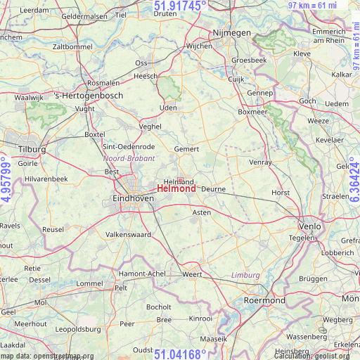
Helmond GPS coordinates[2]
51° 28' 54.012" North, 5° 39' 39.996" East
| Map corner | latitude | longitude |
|---|---|---|
| Upper-left | 51.91745°, | 4.95799° |
| Center: | 51.48167°, | 5.66111° |
| Lower-right: | 51.04168°, | 6.36424° |
| Map W x H: | 97.4×97.4 km | = 60.5×60.5mi |
| max Lat: | 53.48025° ⇑82.3% North |
| Helmond: | 51.48167° |
| min Lat: | ⇓17.7% South 50.76917° |
| min Long | Helmond | max Long |
| 3.38611° | 5.66111° | 7.16528° |
| W 50.4%⇐ | ⇒49.6% E |
Elevation
Elevation of Helmond is 19 m = 62 ft, and this is 4 m = 13 ft above average elevation for this country.
| Max E: |
203 m = 666 ft | 22.9% |
| Helmond | 19 m 62 ft | |
| Avg. | 15 m = 49 ft | |
Min E: |
-6 m = -20 ft | 77.1% |
See also: Helmond elevation on elevation.city.
Geographical zone
Helmond is located in North temperate zone (between Tropic of Cancer and the Arctic Circle). Distance of this North polar circle is 1676.9 km =1042 mi to North.| Distance of | km | miles | from Helmond |
|---|---|---|---|
| North Pole | 4282.8 | 2661.2 | to North |
| Arctic Circle | 1676.9 | 1042 | to North |
| Tropic Cancer | 3118.3 | 1937.6 | to South |
| Equator | 5724.2 | 3556.9 | to South |


Nearby cities:
15 places around Helmond: (largest is in red/bold)
• Aarle-Rixtel
3.5 km =2.2 mi,  333°
333°
• Bakel
6 km =3.7 mi,  66°
66°
• Beek
5.6 km =3.5 mi,  340°
340°
• Brand
3.6 km =2.2 mi,  224°
224°
• De Mortel
7.3 km =4.5 mi,  26°
26°
• Donk
6.7 km =4.2 mi, 340°
• Gemert
8.5 km =5.3 mi,  13°
13°
• Gerwen
6.9 km =4.3 mi,  277°
277°
• Lierop
7.1 km =4.4 mi,  169°
169°
• Lieshout
6.3 km =3.9 mi,  313°
313°
• Mierlo
5.5 km =3.4 mi,  211°
211°
• Nuenen
7.6 km =4.7 mi,  260°
260°
• Schutsboom
3.5 km =2.2 mi,  229°
229°
• Stepekolk
4.5 km =2.8 mi, 228°
• Vlierden
7.9 km =4.9 mi,  121°
121°
Sources, notices
• [Note1] Compared only with cities in Netherlands existing in our database
• [Src1] Map data: © OpenStreetMap contributors (CC-BY-SA)
• [Src2] Other city data from geonames.org with taken over terms of usage.
• [Src3] Geographical zone / Annual Mean Temperature by Robert A. Rohde @ Wikipedia
