Bakel geodata
Bakel (North Brabant) is a populated place; located in Netherlands in Europe/Amsterdam (GMT+2) time zone. With population of 4,140 people, there are 574 cities with bigger population in this country. Compared to other cities in Netherlands, 80.6% of cities are located further ↑North; 54.2% of cities are located further ←West and 82.1% of cities have lower elevation than Bakel. Note1


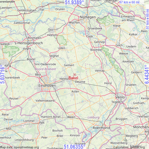
Bakel GPS coordinates[2]
51° 30' 11.988" North, 5° 44' 25.008" East
| Map corner | latitude | longitude |
|---|---|---|
| Upper-left | 51.9389°, | 5.03716° |
| Center: | 51.50333°, | 5.74028° |
| Lower-right: | 51.06355°, | 6.44341° |
| Map W x H: | 97.3×97.3 km | = 60.5×60.5mi |
| max Lat: | 53.48025° ⇑80.6% North |
| Bakel: | 51.50333° |
| min Lat: | ⇓19.4% South 50.76917° |
| min Long | Bakel | max Long |
| 3.38611° | 5.74028° | 7.16528° |
| W 54.2%⇐ | ⇒45.8% E |
Elevation
Elevation of Bakel is 23 m = 75 ft, and this is 8 m = 26 ft above average elevation for this country.
| Max E: |
203 m = 666 ft | 17.9% |
| Bakel | 23 m 75 ft | |
| Avg. | 15 m = 49 ft | |
Min E: |
-6 m = -20 ft | 82.1% |
See also: Netherlands elevation on elevation.city.
Geographical zone
Bakel is located in North temperate zone (between Tropic of Cancer and the Arctic Circle). Distance of this North polar circle is 1674.5 km =1040.5 mi to North.| Distance of | km | miles | from Bakel |
|---|---|---|---|
| North Pole | 4280.4 | 2659.7 | to North |
| Arctic Circle | 1674.5 | 1040.5 | to North |
| Tropic Cancer | 3120.7 | 1939.1 | to South |
| Equator | 5726.6 | 3558.3 | to South |


Nearby cities:
15 places around Bakel: (largest is in red/bold)
• Aarle-Rixtel
7.1 km =4.4 mi,  275°
275°
• Beek
7.9 km =4.9 mi,  291°
291°
• De Mortel
4.6 km =2.9 mi,  331°
331°
• De Rips
7.1 km =4.4 mi,  42°
42°
• Donk
8.6 km =5.3 mi,  296°
296°
• Doonheide
7.7 km =4.8 mi,  335°
335°
• Elsendorp
8.8 km =5.5 mi,  13°
13°
• Gemert
6.8 km =4.2 mi, 329°
• Handel
8.8 km =5.5 mi,  346°
346°
• Helmond
6 km =3.7 mi,  246°
246°
• Milheeze
2.7 km =1.7 mi,  93°
93°
• Ommel
8.8 km =5.5 mi,  176°
176°
• Vlierden
6.6 km =4.1 mi,  169°
169°
• Walsberg
5.4 km =3.4 mi,  126°
126°
• Zeilberg
7.7 km =4.8 mi, 134°
Sources, notices
• [Note1] Compared only with cities in Netherlands existing in our database
• [Src1] Map data: © OpenStreetMap contributors (CC-BY-SA)
• [Src2] Other city data from geonames.org with taken over terms of usage.
• [Src3] Geographical zone / Annual Mean Temperature by Robert A. Rohde @ Wikipedia
