De Koog geodata
De Koog (North Holland) is a populated place; located in Netherlands in Europe/Amsterdam (GMT+2) time zone. With population of 1,025 people, there are 1382 cities with bigger population in this country. Compared to other cities in Netherlands, 88.8% of cities are located further ↓South; 81.3% of cities are located further →East and 58.8% of cities have higher elevation than De Koog. Note1


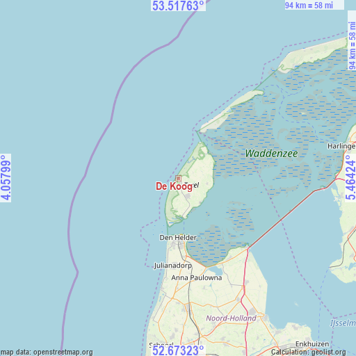
De Koog GPS coordinates[2]
53° 5' 51" North, 4° 45' 39.996" East
| Map corner | latitude | longitude |
|---|---|---|
| Upper-left | 53.51763°, | 4.05799° |
| Center: | 53.0975°, | 4.76111° |
| Lower-right: | 52.67323°, | 5.46424° |
| Map W x H: | 93.9×93.9 km | = 58.3×58.3mi |
| max Lat: | 53.48025° ⇑11.2% North |
| De Koog: | 53.0975° |
| min Lat: | ⇓88.8% South 50.76917° |
| min Long | De Koog | max Long |
| 3.38611° | 4.76111° | 7.16528° |
| W 18.7%⇐ | ⇒81.3% E |
Elevation
Elevation of De Koog is 4 m = 13 ft, and this is 11 m = 36 ft below average elevation for this country.
| Max E: |
203 m = 666 ft | 58.8% |
| Avg. | 15 m = 49 ft | |
| De Koog | 4 m = 13 ft | |
Min E: |
-6 m = -20 ft | 41.2% |
See also: Netherlands elevation on elevation.city.
Geographical zone
De Koog is located in North temperate zone (between Tropic of Cancer and the Arctic Circle). Distance of this North polar circle is 1497.3 km =930.4 mi to North.| Distance of | km | miles | from De Koog |
|---|---|---|---|
| North Pole | 4103.2 | 2549.6 | to North |
| Arctic Circle | 1497.3 | 930.4 | to North |
| Tropic Cancer | 3298 | 2049.3 | to South |
| Equator | 5903.9 | 3668.5 | to South |


Nearby cities:
15 places around De Koog: (largest is in red/bold)
• 't Zand
29 km =18 mi,  180°
180°
• Breezand
23.3 km =14.5 mi,  172°
172°
• Callantsoog
29 km =18 mi,  188°
188°
• De Cocksdorp
9.8 km =6.1 mi,  48°
48°
• Den Burg
5.4 km =3.4 mi,  153°
153°
• Den Helder
15.3 km =9.5 mi, 180°
• Den Oever
25.6 km =15.9 mi,  135°
135°
• Hippolytushoef
25.1 km =15.6 mi, 147°
• Oost-Vlieland
30.5 km =19 mi,  43°
43°
• Oosterend
7.7 km =4.8 mi,  100°
100°
• Oudeschild
8.7 km =5.4 mi, 138°
• Oudesluis
29.4 km =18.3 mi, 173°
• Slootdorp
31.7 km =19.7 mi, 153°
• Westerland
25.3 km =15.7 mi, 153°
• Wieringerwaard
29.9 km =18.6 mi, 166°
Sources, notices
• [Note1] Compared only with cities in Netherlands existing in our database
• [Src1] Map data: © OpenStreetMap contributors (CC-BY-SA)
• [Src2] Other city data from geonames.org with taken over terms of usage.
• [Src3] Geographical zone / Annual Mean Temperature by Robert A. Rohde @ Wikipedia
