Oosterend geodata
Oosterend (North Holland) is a populated place; located in Netherlands in Europe/Amsterdam (GMT+2) time zone. With population of 910 people, there are 1455 cities with bigger population in this country. Compared to other cities in Netherlands, 88.5% of cities are located further ↓South; 77% of cities are located further →East and 65.8% of cities have higher elevation than Oosterend. Note1


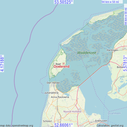
Oosterend GPS coordinates[2]
53° 5' 6" North, 4° 52' 30" East
| Map corner | latitude | longitude |
|---|---|---|
| Upper-left | 53.50525°, | 4.17188° |
| Center: | 53.085°, | 4.875° |
| Lower-right: | 52.66061°, | 5.57813° |
| Map W x H: | 93.9×93.9 km | = 58.3×58.3mi |
| max Lat: | 53.48025° ⇑11.5% North |
| Oosterend: | 53.085° |
| min Lat: | ⇓88.5% South 50.76917° |
| min Long | Oosterend | max Long |
| 3.38611° | 4.875° | 7.16528° |
| W 23%⇐ | ⇒77% E |
Elevation
Elevation of Oosterend is 3 m = 10 ft, and this is 12 m = 39 ft below average elevation for this country.
| Max E: |
203 m = 666 ft | 65.8% |
| Avg. | 15 m = 49 ft | |
| Oosterend | 3 m = 10 ft | |
Min E: |
-6 m = -20 ft | 34.2% |
See also: Netherlands elevation on elevation.city.
Geographical zone
Oosterend is located in North temperate zone (between Tropic of Cancer and the Arctic Circle). Distance of this North polar circle is 1498.7 km =931.2 mi to North.| Distance of | km | miles | from Oosterend |
|---|---|---|---|
| North Pole | 4104.6 | 2550.5 | to North |
| Arctic Circle | 1498.7 | 931.2 | to North |
| Tropic Cancer | 3296.6 | 2048.4 | to South |
| Equator | 5902.5 | 3667.6 | to South |


Nearby cities:
15 places around Oosterend: (largest is in red/bold)
• 't Zand
28.7 km =17.8 mi,  196°
196°
• Breezand
22.2 km =13.8 mi,  192°
192°
• De Cocksdorp
8 km =5 mi,  358°
358°
• De Koog
7.7 km =4.8 mi,  280°
280°
• Den Burg
6.2 km =3.9 mi,  236°
236°
• Den Helder
15.9 km =9.9 mi,  209°
209°
• Den Oever
19.8 km =12.3 mi,  148°
148°
• Hippolytushoef
20.6 km =12.8 mi,  163°
163°
• Oost-Vlieland
27.1 km =16.8 mi,  29°
29°
• Oudeschild
5.4 km =3.4 mi, 200°
• Oudesluis
28.2 km =17.5 mi, 189°
• Slootdorp
27.7 km =17.2 mi,  166°
166°
• Westerland
21.5 km =13.4 mi, 170°
• Wieringerwaard
27.7 km =17.2 mi,  181°
181°
• Wieringerwerf
27.9 km =17.3 mi, 158°
Sources, notices
• [Note1] Compared only with cities in Netherlands existing in our database
• [Src1] Map data: © OpenStreetMap contributors (CC-BY-SA)
• [Src2] Other city data from geonames.org with taken over terms of usage.
• [Src3] Geographical zone / Annual Mean Temperature by Robert A. Rohde @ Wikipedia
