Justvik geodata
Justvik (Vest-Agder) is a populated place; located in Norway in Europe/Oslo (GMT+2) time zone. With population of 1,630 people, there are 233 cities with bigger population in this country. Compared to other cities in Norway, 97.8% of cities are located further ↑North; 66.5% of cities are located further →East and 84.8% of cities have higher elevation than Justvik. Note1


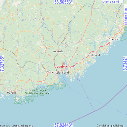
Justvik GPS coordinates[2]
58° 11' 48.876" North, 8° 1' 51.852" East
| Map corner | latitude | longitude |
|---|---|---|
| Upper-left | 58.56553°, | 7.32795° |
| Center: | 58.19691°, | 8.03107° |
| Lower-right: | 57.82443°, | 8.7342° |
| Map W x H: | 82.4×82.4 km | = 51.2×51.2mi |
| max Lat: | 71.04137° ⇑97.8% North |
| Justvik: | 58.19691° |
| min Lat: | ⇓2.2% South 58.0274° |
| min Long | Justvik | max Long |
| 4.71485° | 8.03107° | 31.11066° |
| W 33.5%⇐ | ⇒66.5% E |
Elevation
Elevation of Justvik is 8 m = 26 ft, and this is 96.2 m = 316 ft below average elevation for this country.
| Max E: |
897 m = 2943 ft | 84.8% |
| Avg. | 104.2 m = 342 ft | |
| Justvik | 8 m = 26 ft | |
Min E: |
1 m = 3 ft | 15.2% |
See also: Norway elevation on elevation.city.
Geographical zone
Justvik is located in North temperate zone (between Tropic of Cancer and the Arctic Circle). Distance of this North polar circle is 930.3 km =578.1 mi to North.| Distance of | km | miles | from Justvik |
|---|---|---|---|
| North Pole | 3536.2 | 2197.3 | to North |
| Arctic Circle | 930.3 | 578.1 | to North |
| Tropic Cancer | 3865 | 2401.6 | to South |
| Equator | 6470.9 | 4020.8 | to South |


Nearby cities:
15 places around Justvik: (largest is in red/bold)
• Birkeland
19 km =11.8 mi,  38°
38°
• Birketveit
29.9 km =18.6 mi,  347°
347°
• Grimstad
36.6 km =22.7 mi,  64°
64°
• Helland
29.7 km =18.5 mi,  269°
269°
• Jordtveit
29.1 km =18.1 mi,  73°
73°
• Kristiansand
6 km =3.7 mi,  200°
200°
• Lillesand
21.1 km =13.1 mi, 74°
• Mandal
38.8 km =24.1 mi,  240°
240°
• Nodeland
12.4 km =7.7 mi,  247°
247°
• Skålevik
13.1 km =8.1 mi,  183°
183°
• Strai
6.1 km =3.8 mi,  262°
262°
• Søgne
18.6 km =11.6 mi,  231°
231°
• Tangvall
16.8 km =10.4 mi, 228°
• Tveit
6.7 km =4.2 mi,  52°
52°
• Vennesla
8.7 km =5.4 mi,  336°
336°
Sources, notices
• [Note1] Compared only with cities in Norway existing in our database
• [Src1] Map data: © OpenStreetMap contributors (CC-BY-SA)
• [Src2] Other city data from geonames.org with taken over terms of usage.
• [Src3] Geographical zone / Annual Mean Temperature by Robert A. Rohde @ Wikipedia
