Birkeland geodata
Birkeland (Aust-Agder) is a seat of a second-order administrative division; located in Norway in Europe/Oslo (GMT+2) time zone. With population of 2,254 people, there are 177 cities with bigger population in this country. Compared to other cities in Norway, 96.5% of cities are located further ↑North; 65.5% of cities are located further →East and 53% of cities have lower elevation than Birkeland. Note1


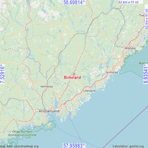
Birkeland GPS coordinates[2]
58° 19' 51.276" North, 8° 13' 56.244" East
| Map corner | latitude | longitude |
|---|---|---|
| Upper-left | 58.69814°, | 7.52916° |
| Center: | 58.33091°, | 8.23229° |
| Lower-right: | 57.95983°, | 8.93541° |
| Map W x H: | 82.1×82.1 km | = 51×51mi |
| max Lat: | 71.04137° ⇑96.5% North |
| Birkeland: | 58.33091° |
| min Lat: | ⇓3.5% South 58.0274° |
| min Long | Birkeland | max Long |
| 4.71485° | 8.23229° | 31.11066° |
| W 34.5%⇐ | ⇒65.5% E |
Elevation
Elevation of Birkeland is 52 m = 171 ft, and this is 52.2 m = 171 ft below average elevation for this country.
| Max E: |
897 m = 2943 ft | 47% |
| Avg. | 104.2 m = 342 ft | |
| Birkeland | 52 m = 171 ft | |
Min E: |
1 m = 3 ft | 53% |
See also: Norway elevation on elevation.city.
Geographical zone
Birkeland is located in North temperate zone (between Tropic of Cancer and the Arctic Circle). Distance of this North polar circle is 915.4 km =568.8 mi to North.| Distance of | km | miles | from Birkeland |
|---|---|---|---|
| North Pole | 3521.3 | 2188 | to North |
| Arctic Circle | 915.4 | 568.8 | to North |
| Tropic Cancer | 3879.9 | 2410.9 | to South |
| Equator | 6485.8 | 4030.1 | to South |


Nearby cities:
15 places around Birkeland: (largest is in red/bold)
• Arendal
34.7 km =21.6 mi,  65°
65°
• Birketveit
23.3 km =14.5 mi,  307°
307°
• Blakstad
30.9 km =19.2 mi,  51°
51°
• Fevik
26.4 km =16.4 mi,  78°
78°
• Grimstad
21.1 km =13.1 mi,  87°
87°
• Jordtveit
17.3 km =10.7 mi,  112°
112°
• Justvik
19 km =11.8 mi,  218°
218°
• Kristiansand
24.7 km =15.3 mi,  214°
214°
• Lillesand
12.5 km =7.8 mi,  137°
137°
• Nodeland
30.3 km =18.8 mi,  229°
229°
• Rykene
25.3 km =15.7 mi, 69°
• Skålevik
30.7 km =19.1 mi,  204°
204°
• Strai
23.8 km =14.8 mi, 228°
• Tveit
12.6 km =7.8 mi, 210°
• Vennesla
16.7 km =10.4 mi,  245°
245°
Sources, notices
• [Note1] Compared only with cities in Norway existing in our database
• [Src1] Map data: © OpenStreetMap contributors (CC-BY-SA)
• [Src2] Other city data from geonames.org with taken over terms of usage.
• [Src3] Geographical zone / Annual Mean Temperature by Robert A. Rohde @ Wikipedia
