Vikersund geodata
Vikersund (Buskerud) is a seat of a second-order administrative division; located in Norway in Europe/Oslo (GMT+2) time zone. With population of 2,448 people, there are 160 cities with bigger population in this country. Compared to other cities in Norway, 65.5% of cities are located further ↑North; 51.7% of cities are located further →East and 64.6% of cities have lower elevation than Vikersund. Note1


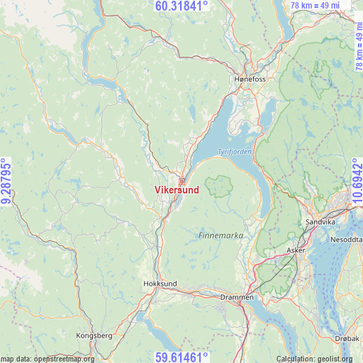
Vikersund GPS coordinates[2]
59° 58' 6.168" North, 9° 59' 27.852" East
| Map corner | latitude | longitude |
|---|---|---|
| Upper-left | 60.31841°, | 9.28795° |
| Center: | 59.96838°, | 9.99107° |
| Lower-right: | 59.61461°, | 10.6942° |
| Map W x H: | 78.3×78.3 km | = 48.7×48.7mi |
| max Lat: | 71.04137° ⇑65.5% North |
| Vikersund: | 59.96838° |
| min Lat: | ⇓34.5% South 58.0274° |
| min Long | Vikersund | max Long |
| 4.71485° | 9.99107° | 31.11066° |
| W 48.3%⇐ | ⇒51.7% E |
Elevation
Elevation of Vikersund is 90 m = 295 ft, and this is 14.2 m = 47 ft below average elevation for this country.
| Max E: |
897 m = 2943 ft | 35.4% |
| Avg. | 104.2 m = 342 ft | |
| Vikersund | 90 m = 295 ft | |
Min E: |
1 m = 3 ft | 64.6% |
See also: Norway elevation on elevation.city.
Geographical zone
Vikersund is located in North temperate zone (between Tropic of Cancer and the Arctic Circle). Distance of this North polar circle is 733.3 km =455.7 mi to North.| Distance of | km | miles | from Vikersund |
|---|---|---|---|
| North Pole | 3339.2 | 2074.9 | to North |
| Arctic Circle | 733.3 | 455.7 | to North |
| Tropic Cancer | 4061.9 | 2523.9 | to South |
| Equator | 6667.9 | 4143.2 | to South |


Nearby cities:
15 places around Vikersund: (largest is in red/bold)
• Asker
29.1 km =18.1 mi,  121°
121°
• Drammen
27.7 km =17.2 mi,  154°
154°
• Hokksund
22.4 km =13.9 mi,  191°
191°
• Hønefoss
26.6 km =16.5 mi,  33°
33°
• Lampeland
27.4 km =17 mi,  237°
237°
• Lierbyen
24.7 km =15.3 mi, 145°
• Mjøndalen
24.3 km =15.1 mi,  175°
175°
• Prestfoss
21.5 km =13.4 mi,  292°
292°
• Skui
25.8 km =16 mi,  100°
100°
• Smestad
24.9 km =15.5 mi, 98°
• Sundvollen
20.5 km =12.7 mi,  59°
59°
• Sylling
18.7 km =11.6 mi, 116°
• Tranby
23.3 km =14.5 mi,  139°
139°
• Tyristrand
14.3 km =8.9 mi,  24°
24°
• Vik
20.1 km =12.5 mi,  52°
52°
Sources, notices
• [Note1] Compared only with cities in Norway existing in our database
• [Src1] Map data: © OpenStreetMap contributors (CC-BY-SA)
• [Src2] Other city data from geonames.org with taken over terms of usage.
• [Src3] Geographical zone / Annual Mean Temperature by Robert A. Rohde @ Wikipedia
