Tyristrand geodata
Tyristrand (Buskerud) is a populated place; located in Norway in Europe/Oslo (GMT+2) time zone. With population of 795 people, there are 358 cities with bigger population in this country. Compared to other cities in Norway, 62.3% of cities are located further ↑North; 50.2% of cities are located further →East and 66% of cities have lower elevation than Tyristrand. Note1


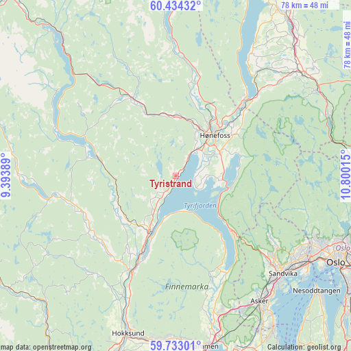
Tyristrand GPS coordinates[2]
60° 5' 7.908" North, 10° 5' 49.272" East
| Map corner | latitude | longitude |
|---|---|---|
| Upper-left | 60.43432°, | 9.39389° |
| Center: | 60.08553°, | 10.09702° |
| Lower-right: | 59.73301°, | 10.80015° |
| Map W x H: | 78×78 km | = 48.5×48.5mi |
| max Lat: | 71.04137° ⇑62.3% North |
| Tyristrand: | 60.08553° |
| min Lat: | ⇓37.7% South 58.0274° |
| min Long | Tyristrand | max Long |
| 4.71485° | 10.09702° | 31.11066° |
| W 49.8%⇐ | ⇒50.2% E |
Elevation
Elevation of Tyristrand is 100 m = 328 ft, and this is 4.2 m = 14 ft below average elevation for this country.
| Max E: |
897 m = 2943 ft | 34% |
| Avg. | 104.2 m = 342 ft | |
| Tyristrand | 100 m = 328 ft | |
Min E: |
1 m = 3 ft | 66% |
See also: Norway elevation on elevation.city.
Geographical zone
Tyristrand is located in North temperate zone (between Tropic of Cancer and the Arctic Circle). Distance of this North polar circle is 720.3 km =447.6 mi to North.| Distance of | km | miles | from Tyristrand |
|---|---|---|---|
| North Pole | 3326.2 | 2066.8 | to North |
| Arctic Circle | 720.3 | 447.6 | to North |
| Tropic Cancer | 4075 | 2532.1 | to South |
| Equator | 6680.9 | 4151.3 | to South |


Nearby cities:
15 places around Tyristrand: (largest is in red/bold)
• Billingstad
31.7 km =19.7 mi,  137°
137°
• Hallingby
21.2 km =13.2 mi,  13°
13°
• Hønefoss
12.7 km =7.9 mi,  43°
43°
• Jevnaker
23.5 km =14.6 mi, 43°
• Noresund
28.2 km =17.5 mi,  291°
291°
• Prestfoss
26 km =16.2 mi,  259°
259°
• Sandvika
32.3 km =20.1 mi,  132°
132°
• Skui
26.2 km =16.3 mi, 132°
• Smestad
25.2 km =15.7 mi, 132°
• Sokna
19.4 km =12.1 mi,  331°
331°
• Sundvollen
11.9 km =7.4 mi,  102°
102°
• Sylling
24 km =14.9 mi,  153°
153°
• Tranby
32.1 km =19.9 mi,  163°
163°
• Vik
10.1 km =6.3 mi, 95°
• Vikersund
14.3 km =8.9 mi,  204°
204°
Sources, notices
• [Note1] Compared only with cities in Norway existing in our database
• [Src1] Map data: © OpenStreetMap contributors (CC-BY-SA)
• [Src2] Other city data from geonames.org with taken over terms of usage.
• [Src3] Geographical zone / Annual Mean Temperature by Robert A. Rohde @ Wikipedia
