Sundvollen geodata
Sundvollen (Buskerud) is a populated locality; located in Norway in Europe/Oslo (GMT+2) time zone. With population of 718 people, there are 377 cities with bigger population in this country. Compared to other cities in Norway, 63.1% of cities are located further ↑North; 54.4% of cities are located further ←West and 62.5% of cities have lower elevation than Sundvollen. Note1


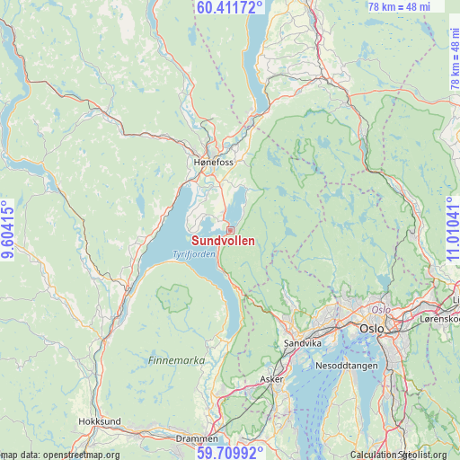
Sundvollen GPS coordinates[2]
60° 3' 45.684" North, 10° 18' 26.208" East
| Map corner | latitude | longitude |
|---|---|---|
| Upper-left | 60.41172°, | 9.60415° |
| Center: | 60.06269°, | 10.30728° |
| Lower-right: | 59.70992°, | 11.01041° |
| Map W x H: | 78×78 km | = 48.5×48.5mi |
| max Lat: | 71.04137° ⇑63.1% North |
| Sundvollen: | 60.06269° |
| min Lat: | ⇓36.9% South 58.0274° |
| min Long | Sundvollen | max Long |
| 4.71485° | 10.30728° | 31.11066° |
| W 54.4%⇐ | ⇒45.6% E |
Elevation
Elevation of Sundvollen is 80 m = 262 ft, and this is 24.2 m = 79 ft below average elevation for this country.
| Max E: |
897 m = 2943 ft | 37.5% |
| Avg. | 104.2 m = 342 ft | |
| Sundvollen | 80 m = 262 ft | |
Min E: |
1 m = 3 ft | 62.5% |
See also: Norway elevation on elevation.city.
Geographical zone
Sundvollen is located in North temperate zone (between Tropic of Cancer and the Arctic Circle). Distance of this North polar circle is 722.8 km =449.1 mi to North.| Distance of | km | miles | from Sundvollen |
|---|---|---|---|
| North Pole | 3328.7 | 2068.4 | to North |
| Arctic Circle | 722.8 | 449.1 | to North |
| Tropic Cancer | 4072.4 | 2530.5 | to South |
| Equator | 6678.3 | 4149.7 | to South |


Nearby cities:
15 places around Sundvollen: (largest is in red/bold)
• Asker
26.5 km =16.5 mi,  164°
164°
• Billingstad
23 km =14.3 mi,  154°
154°
• Hallingby
24.2 km =15 mi,  343°
343°
• Hønefoss
12 km =7.5 mi,  346°
346°
• Jevnaker
20.2 km =12.6 mi,  12°
12°
• Lysaker
24.9 km =15.5 mi,  132°
132°
• Sandvika
22.7 km =14.1 mi, 147°
• Sjølyststranda
26 km =16.2 mi, 127°
• Skui
16.9 km =10.5 mi, 152°
• Smestad
16 km =9.9 mi, 154°
• Sylling
18.9 km =11.7 mi,  182°
182°
• Tranby
28.4 km =17.6 mi,  185°
185°
• Tyristrand
11.9 km =7.4 mi,  282°
282°
• Vik
2.2 km =1.4 mi,  315°
315°
• Vikersund
20.5 km =12.7 mi,  239°
239°
Sources, notices
• [Note1] Compared only with cities in Norway existing in our database
• [Src1] Map data: © OpenStreetMap contributors (CC-BY-SA)
• [Src2] Other city data from geonames.org with taken over terms of usage.
• [Src3] Geographical zone / Annual Mean Temperature by Robert A. Rohde @ Wikipedia
