Hønefoss geodata
Hønefoss (Buskerud) is a seat of a second-order administrative division; located in Norway in Europe/Oslo (GMT+2) time zone. With population of 13,678 people, there are 36 cities with bigger population in this country. Compared to other cities in Norway, 60.8% of cities are located further ↑North; 52.5% of cities are located further ←West and 60.9% of cities have lower elevation than Hønefoss. Note1


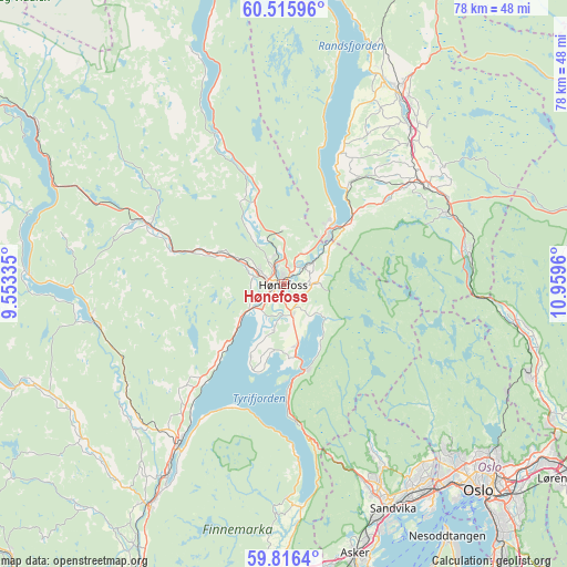
Hønefoss GPS coordinates[2]
60° 10' 4.944" North, 10° 15' 23.292" East
| Map corner | latitude | longitude |
|---|---|---|
| Upper-left | 60.51596°, | 9.55335° |
| Center: | 60.16804°, | 10.25647° |
| Lower-right: | 59.8164°, | 10.9596° |
| Map W x H: | 77.8×77.8 km | = 48.3×48.3mi |
| max Lat: | 71.04137° ⇑60.8% North |
| Hønefoss: | 60.16804° |
| min Lat: | ⇓39.2% South 58.0274° |
| min Long | Hønefoss | max Long |
| 4.71485° | 10.25647° | 31.11066° |
| W 52.5%⇐ | ⇒47.5% E |
Elevation
Elevation of Hønefoss is 70 m = 230 ft, and this is 34.2 m = 112 ft below average elevation for this country.
| Max E: |
897 m = 2943 ft | 39.1% |
| Avg. | 104.2 m = 342 ft | |
| Hønefoss | 70 m = 230 ft | |
Min E: |
1 m = 3 ft | 60.9% |
See also: Norway elevation on elevation.city.
Geographical zone
Hønefoss is located in North temperate zone (between Tropic of Cancer and the Arctic Circle). Distance of this North polar circle is 711.1 km =441.9 mi to North.| Distance of | km | miles | from Hønefoss |
|---|---|---|---|
| North Pole | 3317 | 2061.1 | to North |
| Arctic Circle | 711.1 | 441.9 | to North |
| Tropic Cancer | 4084.1 | 2537.7 | to South |
| Equator | 6690.1 | 4157 | to South |


Nearby cities:
15 places around Hønefoss: (largest is in red/bold)
• Billingstad
34.9 km =21.7 mi,  158°
158°
• Grua
24.5 km =15.2 mi,  66°
66°
• Hallingby
12.2 km =7.6 mi,  340°
340°
• Jaren
30.1 km =18.7 mi,  33°
33°
• Jevnaker
10.8 km =6.7 mi,  42°
42°
• Roa
24.1 km =15 mi,  55°
55°
• Sandvika
34.3 km =21.3 mi,  153°
153°
• Skui
28.8 km =17.9 mi, 158°
• Smestad
27.9 km =17.3 mi, 159°
• Sokna
19.8 km =12.3 mi,  293°
293°
• Sundvollen
12 km =7.5 mi,  166°
166°
• Sylling
30.6 km =19 mi,  176°
176°
• Tyristrand
12.7 km =7.9 mi,  223°
223°
• Vik
10.2 km =6.3 mi, 172°
• Vikersund
26.6 km =16.5 mi,  213°
213°
Sources, notices
• [Note1] Compared only with cities in Norway existing in our database
• [Src1] Map data: © OpenStreetMap contributors (CC-BY-SA)
• [Src2] Other city data from geonames.org with taken over terms of usage.
• [Src3] Geographical zone / Annual Mean Temperature by Robert A. Rohde @ Wikipedia
