Tonstad geodata
Tonstad (Vest-Agder) is a seat of a second-order administrative division; located in Norway in Europe/Oslo (GMT+2) time zone. With population of 751 people, there are 367 cities with bigger population in this country. Compared to other cities in Norway, 93.5% of cities are located further ↑North; 75.8% of cities are located further →East and 60.4% of cities have lower elevation than Tonstad. Note1


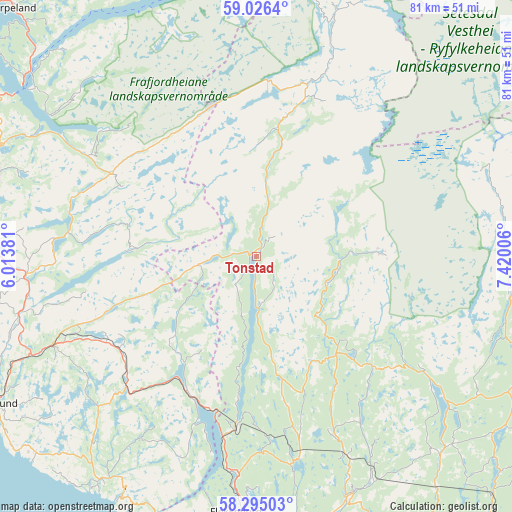
Tonstad GPS coordinates[2]
58° 39' 45.468" North, 6° 43' 0.984" East
| Map corner | latitude | longitude |
|---|---|---|
| Upper-left | 59.0264°, | 6.01381° |
| Center: | 58.66263°, | 6.71694° |
| Lower-right: | 58.29503°, | 7.42006° |
| Map W x H: | 81.3×81.3 km | = 50.5×50.5mi |
| max Lat: | 71.04137° ⇑93.5% North |
| Tonstad: | 58.66263° |
| min Lat: | ⇓6.5% South 58.0274° |
| min Long | Tonstad | max Long |
| 4.71485° | 6.71694° | 31.11066° |
| W 24.2%⇐ | ⇒75.8% E |
Elevation
Elevation of Tonstad is 68 m = 223 ft, and this is 36.2 m = 119 ft below average elevation for this country.
| Max E: |
897 m = 2943 ft | 39.6% |
| Avg. | 104.2 m = 342 ft | |
| Tonstad | 68 m = 223 ft | |
Min E: |
1 m = 3 ft | 60.4% |
See also: Norway elevation on elevation.city.
Geographical zone
Tonstad is located in North temperate zone (between Tropic of Cancer and the Arctic Circle). Distance of this North polar circle is 878.5 km =545.9 mi to North.| Distance of | km | miles | from Tonstad |
|---|---|---|---|
| North Pole | 3484.4 | 2165.1 | to North |
| Arctic Circle | 878.5 | 545.9 | to North |
| Tropic Cancer | 3916.8 | 2433.8 | to South |
| Equator | 6522.7 | 4053 | to South |


Nearby cities:
15 places around Tonstad: (largest is in red/bold)
• Egersund
47.8 km =29.7 mi,  240°
240°
• Flekkefjord
40.8 km =25.4 mi,  184°
184°
• Forsand
44.3 km =27.5 mi,  307°
307°
• Hauge i Dalane
43.6 km =27.1 mi,  215°
215°
• Hellvik
52.8 km =32.8 mi,  247°
247°
• Jørpeland
55.8 km =34.7 mi,  315°
315°
• Konsmo
56 km =34.8 mi,  138°
138°
• Kyrkjebygda
40.7 km =25.3 mi,  97°
97°
• Liknes
41.5 km =25.8 mi,  159°
159°
• Moi
24.8 km =15.4 mi,  202°
202°
• Oltedal
43.4 km =27 mi,  295°
295°
• Sira
27.1 km =16.8 mi,  186°
186°
• Tingvatn
43.2 km =26.8 mi, 137°
• Vikeså
36.3 km =22.6 mi,  265°
265°
• Ålgård
51.2 km =31.8 mi,  282°
282°
Sources, notices
• [Note1] Compared only with cities in Norway existing in our database
• [Src1] Map data: © OpenStreetMap contributors (CC-BY-SA)
• [Src2] Other city data from geonames.org with taken over terms of usage.
• [Src3] Geographical zone / Annual Mean Temperature by Robert A. Rohde @ Wikipedia
