Ulvik geodata
Ulvik (Hordaland) is a seat of a second-order administrative division; located in Norway in Europe/Oslo (GMT+2) time zone. With population of 675 people, there are 390 cities with bigger population in this country. Compared to other cities in Norway, 51.1% of cities are located further ↑North; 74.1% of cities are located further →East and 61.1% of cities have higher elevation than Ulvik. Note1


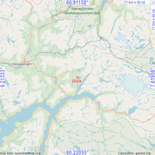
Ulvik GPS coordinates[2]
60° 34' 4.476" North, 6° 54' 59.22" East
| Map corner | latitude | longitude |
|---|---|---|
| Upper-left | 60.91158°, | 6.21333° |
| Center: | 60.56791°, | 6.91645° |
| Lower-right: | 60.22055°, | 7.61958° |
| Map W x H: | 76.8×76.8 km | = 47.7×47.7mi |
| max Lat: | 71.04137° ⇑51.1% North |
| Ulvik: | 60.56791° |
| min Lat: | ⇓48.9% South 58.0274° |
| min Long | Ulvik | max Long |
| 4.71485° | 6.91645° | 31.11066° |
| W 25.9%⇐ | ⇒74.1% E |
Elevation
Elevation of Ulvik is 26 m = 85 ft, and this is 78.2 m = 257 ft below average elevation for this country.
| Max E: |
897 m = 2943 ft | 61.1% |
| Avg. | 104.2 m = 342 ft | |
| Ulvik | 26 m = 85 ft | |
Min E: |
1 m = 3 ft | 38.9% |
See also: Norway elevation on elevation.city.
Geographical zone
Ulvik is located in North temperate zone (between Tropic of Cancer and the Arctic Circle). Distance of this North polar circle is 666.7 km =414.3 mi to North.| Distance of | km | miles | from Ulvik |
|---|---|---|---|
| North Pole | 3272.5 | 2033.4 | to North |
| Arctic Circle | 666.7 | 414.3 | to North |
| Tropic Cancer | 4128.6 | 2565.4 | to South |
| Equator | 6734.5 | 4184.6 | to South |


Nearby cities:
15 places around Ulvik: (largest is in red/bold)
• Aurlandsvangen
40.3 km =25 mi,  21°
21°
• Dale
60 km =37.3 mi,  271°
271°
• Eidfjord
14 km =8.7 mi,  142°
142°
• Granvin
11.8 km =7.3 mi,  245°
245°
• Indre Ålvik
30.5 km =19 mi,  240°
240°
• Jondal
48.8 km =30.3 mi,  228°
228°
• Kinsarvik
23.9 km =14.9 mi,  206°
206°
• Lofthus
29.7 km =18.5 mi, 208°
• Norheimsund
47.6 km =29.6 mi, 242°
• Odda
59.1 km =36.7 mi,  200°
200°
• Tyssedal
53.9 km =33.5 mi, 201°
• Vik
57.4 km =35.7 mi,  341°
341°
• Vikøyri
60.6 km =37.7 mi, 342°
• Voss
28.2 km =17.5 mi,  283°
283°
• Øystese
44.4 km =27.6 mi, 243°
Sources, notices
• [Note1] Compared only with cities in Norway existing in our database
• [Src1] Map data: © OpenStreetMap contributors (CC-BY-SA)
• [Src2] Other city data from geonames.org with taken over terms of usage.
• [Src3] Geographical zone / Annual Mean Temperature by Robert A. Rohde @ Wikipedia
