Innbygda geodata
Innbygda (Hedmark) is a seat of a second-order administrative division; located in Norway in Europe/Oslo (GMT+2) time zone. With population of 2,250 people, there are 178 cities with bigger population in this country. Compared to other cities in Norway, 59.3% of cities are located further ↓South; 82.8% of cities are located further ←West and 93.4% of cities have lower elevation than Innbygda. Note1


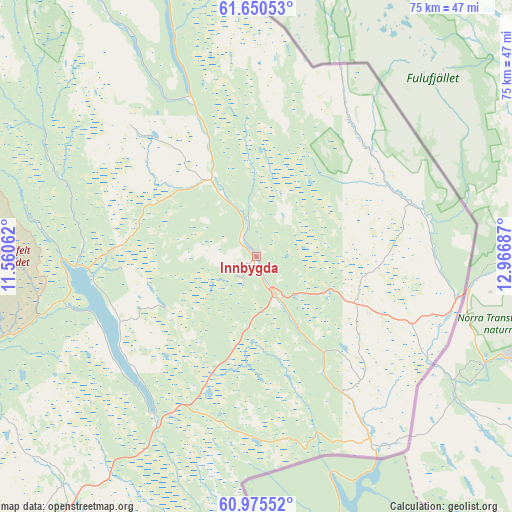
Innbygda GPS coordinates[2]
61° 18' 53.424" North, 12° 15' 49.464" East
| Map corner | latitude | longitude |
|---|---|---|
| Upper-left | 61.65053°, | 11.56062° |
| Center: | 61.31484°, | 12.26374° |
| Lower-right: | 60.97552°, | 12.96687° |
| Map W x H: | 75.1×75.1 km | = 46.7×46.7mi |
| max Lat: | 71.04137° ⇑40.7% North |
| Innbygda: | 61.31484° |
| min Lat: | ⇓59.3% South 58.0274° |
| min Long | Innbygda | max Long |
| 4.71485° | 12.26374° | 31.11066° |
| W 82.8%⇐ | ⇒17.2% E |
Elevation
Elevation of Innbygda is 380 m = 1247 ft, and this is 275.8 m = 905 ft above average elevation for this country.
| Max E: |
897 m = 2943 ft | 6.6% |
| Innbygda | 380 m 1247 ft | |
| Avg. | 104.2 m = 342 ft | |
Min E: |
1 m = 3 ft | 93.4% |
See also: Norway elevation on elevation.city.
Geographical zone
Innbygda is located in North temperate zone (between Tropic of Cancer and the Arctic Circle). Distance of this North polar circle is 583.6 km =362.6 mi to North.| Distance of | km | miles | from Innbygda |
|---|---|---|---|
| North Pole | 3189.5 | 1981.9 | to North |
| Arctic Circle | 583.6 | 362.6 | to North |
| Tropic Cancer | 4211.7 | 2617 | to South |
| Equator | 6817.6 | 4236.3 | to South |


Nearby cities:
15 places around Innbygda: (largest is in red/bold)
• Bergset
89.7 km =55.7 mi,  315°
315°
• Brumunddal
86 km =53.4 mi,  235°
235°
• Elverum
61.1 km =38 mi,  218°
218°
• Engerdal
52 km =32.3 mi,  341°
341°
• Flisa
79.2 km =49.2 mi,  189°
189°
• Hamar
86.5 km =53.7 mi,  228°
228°
• Hof
85.7 km =53.3 mi, 188°
• Ilseng
81.9 km =50.9 mi, 222°
• Koppang
70.7 km =43.9 mi,  293°
293°
• Løten
74.1 km =46 mi, 221°
• Rena
51.9 km =32.2 mi,  246°
246°
• Stange
87.9 km =54.6 mi, 220°
• Svarstad
70.1 km =43.6 mi,  307°
307°
• Våler
75.2 km =46.7 mi,  197°
197°
• Ådalsbruk
77.2 km =48 mi, 221°
Sources, notices
• [Note1] Compared only with cities in Norway existing in our database
• [Src1] Map data: © OpenStreetMap contributors (CC-BY-SA)
• [Src2] Other city data from geonames.org with taken over terms of usage.
• [Src3] Geographical zone / Annual Mean Temperature by Robert A. Rohde @ Wikipedia
