Ilseng geodata
Ilseng (Hedmark) is a populated place; located in Norway in Europe/Oslo (GMT+2) time zone. With population of 876 people, there are 340 cities with bigger population in this country. Compared to other cities in Norway, 52.1% of cities are located further ↓South; 72.9% of cities are located further ←West and 77.4% of cities have lower elevation than Ilseng. Note1


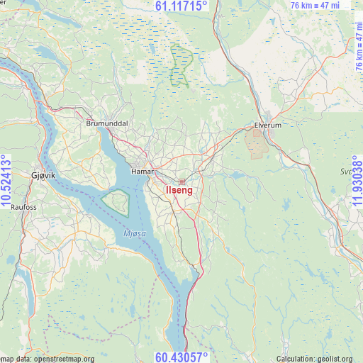
Ilseng GPS coordinates[2]
60° 46' 32.52" North, 11° 13' 38.1" East
| Map corner | latitude | longitude |
|---|---|---|
| Upper-left | 61.11715°, | 10.52413° |
| Center: | 60.7757°, | 11.22725° |
| Lower-right: | 60.43057°, | 11.93038° |
| Map W x H: | 76.3×76.3 km | = 47.4×47.4mi |
| max Lat: | 71.04137° ⇑47.9% North |
| Ilseng: | 60.7757° |
| min Lat: | ⇓52.1% South 58.0274° |
| min Long | Ilseng | max Long |
| 4.71485° | 11.22725° | 31.11066° |
| W 72.9%⇐ | ⇒27.1% E |
Elevation
Elevation of Ilseng is 160 m = 525 ft, and this is 55.8 m = 183 ft above average elevation for this country.
| Max E: |
897 m = 2943 ft | 22.6% |
| Ilseng | 160 m 525 ft | |
| Avg. | 104.2 m = 342 ft | |
Min E: |
1 m = 3 ft | 77.4% |
See also: Norway elevation on elevation.city.
Geographical zone
Ilseng is located in North temperate zone (between Tropic of Cancer and the Arctic Circle). Distance of this North polar circle is 643.5 km =399.9 mi to North.| Distance of | km | miles | from Ilseng |
|---|---|---|---|
| North Pole | 3249.4 | 2019.1 | to North |
| Arctic Circle | 643.5 | 399.9 | to North |
| Tropic Cancer | 4151.7 | 2579.7 | to South |
| Equator | 6757.6 | 4199 | to South |


Nearby cities:
15 places around Ilseng: (largest is in red/bold)
• Brumunddal
19.5 km =12.1 mi,  306°
306°
• Eina
37.9 km =23.5 mi,  244°
244°
• Elverum
21.7 km =13.5 mi,  56°
56°
• Gjøvik
29.2 km =18.1 mi,  274°
274°
• Hamar
8.9 km =5.5 mi,  283°
283°
• Kolbu
29.7 km =18.5 mi, 242°
• Lena
25.2 km =15.7 mi, 243°
• Løten
7.9 km =4.9 mi,  52°
52°
• Moelv
33.5 km =20.8 mi,  301°
301°
• Raufoss
33.8 km =21 mi,  260°
260°
• Reinsvoll
34.6 km =21.5 mi,  252°
252°
• Skreia
21 km =13 mi,  229°
229°
• Stange
6.7 km =4.2 mi,  195°
195°
• Våler
35 km =21.7 mi,  109°
109°
• Ådalsbruk
5 km =3.1 mi, 62°
Sources, notices
• [Note1] Compared only with cities in Norway existing in our database
• [Src1] Map data: © OpenStreetMap contributors (CC-BY-SA)
• [Src2] Other city data from geonames.org with taken over terms of usage.
• [Src3] Geographical zone / Annual Mean Temperature by Robert A. Rohde @ Wikipedia
