Hof geodata
Hof (Hedmark) is a populated place; located in Norway in Europe/Oslo (GMT+2) time zone. With population of 809 people, there are 355 cities with bigger population in this country. Compared to other cities in Norway, 51.4% of cities are located further ↑North; 81.3% of cities are located further ←West and 79.3% of cities have lower elevation than Hof. Note1


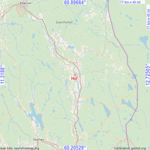
Hof GPS coordinates[2]
60° 33' 10.116" North, 12° 1' 18.912" East
| Map corner | latitude | longitude |
|---|---|---|
| Upper-left | 60.89664°, | 11.3188° |
| Center: | 60.55281°, | 12.02192° |
| Lower-right: | 60.20529°, | 12.72505° |
| Map W x H: | 76.9×76.9 km | = 47.8×47.8mi |
| max Lat: | 71.04137° ⇑51.4% North |
| Hof: | 60.55281° |
| min Lat: | ⇓48.6% South 58.0274° |
| min Long | Hof | max Long |
| 4.71485° | 12.02192° | 31.11066° |
| W 81.3%⇐ | ⇒18.7% E |
Elevation
Elevation of Hof is 162 m = 531 ft, and this is 57.8 m = 190 ft above average elevation for this country.
| Max E: |
897 m = 2943 ft | 20.7% |
| Hof | 162 m 531 ft | |
| Avg. | 104.2 m = 342 ft | |
Min E: |
1 m = 3 ft | 79.3% |
See also: Norway elevation on elevation.city.
Geographical zone
Hof is located in North temperate zone (between Tropic of Cancer and the Arctic Circle). Distance of this North polar circle is 668.3 km =415.3 mi to North.| Distance of | km | miles | from Hof |
|---|---|---|---|
| North Pole | 3274.2 | 2034.5 | to North |
| Arctic Circle | 668.3 | 415.3 | to North |
| Tropic Cancer | 4126.9 | 2564.3 | to South |
| Equator | 6732.8 | 4183.6 | to South |


Nearby cities:
15 places around Hof: (largest is in red/bold)
• Eidsvoll
48.4 km =30.1 mi,  239°
239°
• Elverum
44.3 km =27.5 mi,  325°
325°
• Flisa
6.7 km =4.2 mi,  354°
354°
• Hurdal
53.9 km =33.5 mi,  255°
255°
• Ilseng
49.9 km =31 mi,  299°
299°
• Kirkenær
10.7 km =6.6 mi,  169°
169°
• Kongsvinger
40.3 km =25 mi,  181°
181°
• Løten
47.4 km =29.5 mi,  308°
308°
• Roverud
33.3 km =20.7 mi, 177°
• Sand
31.9 km =19.8 mi, 235°
• Skarnes
38 km =23.6 mi,  209°
209°
• Spetalen
41.6 km =25.8 mi,  189°
189°
• Stange
48.7 km =30.3 mi,  292°
292°
• Våler
16.7 km =10.4 mi,  322°
322°
• Ådalsbruk
47.4 km =29.5 mi, 304°
Sources, notices
• [Note1] Compared only with cities in Norway existing in our database
• [Src1] Map data: © OpenStreetMap contributors (CC-BY-SA)
• [Src2] Other city data from geonames.org with taken over terms of usage.
• [Src3] Geographical zone / Annual Mean Temperature by Robert A. Rohde @ Wikipedia
