Ådalsbruk geodata
Ådalsbruk (Hedmark) is a populated place; located in Norway in Europe/Oslo (GMT+2) time zone. With population of 552 people, there are 443 cities with bigger population in this country. Compared to other cities in Norway, 53% of cities are located further ↓South; 74.7% of cities are located further ←West and 85.3% of cities have lower elevation than Ådalsbruk. Note1


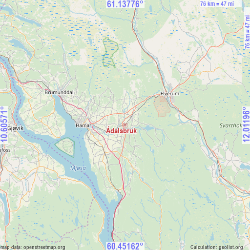
Ådalsbruk GPS coordinates[2]
60° 47' 47.508" North, 11° 18' 31.788" East
| Map corner | latitude | longitude |
|---|---|---|
| Upper-left | 61.13776°, | 10.60571° |
| Center: | 60.79653°, | 11.30883° |
| Lower-right: | 60.45162°, | 12.01196° |
| Map W x H: | 76.3×76.3 km | = 47.4×47.4mi |
| max Lat: | 71.04137° ⇑47% North |
| Ådalsbruk: | 60.79653° |
| min Lat: | ⇓53% South 58.0274° |
| min Long | Ådalsbruk | max Long |
| 4.71485° | 11.30883° | 31.11066° |
| W 74.7%⇐ | ⇒25.3% E |
Elevation
Elevation of Ådalsbruk is 205 m = 673 ft, and this is 100.8 m = 331 ft above average elevation for this country.
| Max E: |
897 m = 2943 ft | 14.7% |
| Ådalsbruk | 205 m 673 ft | |
| Avg. | 104.2 m = 342 ft | |
Min E: |
1 m = 3 ft | 85.3% |
See also: Norway elevation on elevation.city.
Geographical zone
Ådalsbruk is located in North temperate zone (between Tropic of Cancer and the Arctic Circle). Distance of this North polar circle is 641.2 km =398.4 mi to North.| Distance of | km | miles | from Ådalsbruk |
|---|---|---|---|
| North Pole | 3247.1 | 2017.7 | to North |
| Arctic Circle | 641.2 | 398.4 | to North |
| Tropic Cancer | 4154 | 2581.2 | to South |
| Equator | 6759.9 | 4200.4 | to South |


Nearby cities:
15 places around Ådalsbruk: (largest is in red/bold)
• Brumunddal
22.1 km =13.7 mi,  295°
295°
• Elverum
16.7 km =10.4 mi,  55°
55°
• Gjøvik
33.5 km =20.8 mi,  269°
269°
• Hamar
13.1 km =8.1 mi, 269°
• Ilseng
5 km =3.1 mi,  242°
242°
• Kolbu
34.7 km =21.6 mi, 242°
• Lena
30.2 km =18.8 mi, 243°
• Løten
3.1 km =1.9 mi,  35°
35°
• Moelv
36.3 km =22.6 mi,  294°
294°
• Raufoss
38.6 km =24 mi,  258°
258°
• Reinsvoll
39.5 km =24.5 mi,  250°
250°
• Rena
37.5 km =23.3 mi,  5°
5°
• Skreia
25.8 km =16 mi,  231°
231°
• Stange
10.7 km =6.6 mi,  215°
215°
• Våler
31.8 km =19.8 mi,  115°
115°
Sources, notices
• [Note1] Compared only with cities in Norway existing in our database
• [Src1] Map data: © OpenStreetMap contributors (CC-BY-SA)
• [Src2] Other city data from geonames.org with taken over terms of usage.
• [Src3] Geographical zone / Annual Mean Temperature by Robert A. Rohde @ Wikipedia
