Risør geodata
Risør (Aust-Agder) is a seat of a second-order administrative division; located in Norway in Europe/Oslo (GMT+2) time zone. With population of 4,475 people, there are 100 cities with bigger population in this country. Compared to other cities in Norway, 93.2% of cities are located further ↑North; 57.9% of cities are located further →East and 82.9% of cities have higher elevation than Risør. Note1


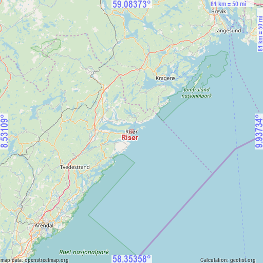
Risør GPS coordinates[2]
58° 43' 14.052" North, 9° 14' 3.192" East
| Map corner | latitude | longitude |
|---|---|---|
| Upper-left | 59.08373°, | 8.53109° |
| Center: | 58.72057°, | 9.23422° |
| Lower-right: | 58.35358°, | 9.93734° |
| Map W x H: | 81.2×81.2 km | = 50.5×50.5mi |
| max Lat: | 71.04137° ⇑93.2% North |
| Risør: | 58.72057° |
| min Lat: | ⇓6.8% South 58.0274° |
| min Long | Risør | max Long |
| 4.71485° | 9.23422° | 31.11066° |
| W 42.1%⇐ | ⇒57.9% E |
Elevation
Elevation of Risør is 9 m = 30 ft, and this is 95.2 m = 312 ft below average elevation for this country.
| Max E: |
897 m = 2943 ft | 82.9% |
| Avg. | 104.2 m = 342 ft | |
| Risør | 9 m = 30 ft | |
Min E: |
1 m = 3 ft | 17.1% |
See also: Norway elevation on elevation.city.
Geographical zone
Risør is located in North temperate zone (between Tropic of Cancer and the Arctic Circle). Distance of this North polar circle is 872.1 km =541.9 mi to North.| Distance of | km | miles | from Risør |
|---|---|---|---|
| North Pole | 3477.9 | 2161.1 | to North |
| Arctic Circle | 872.1 | 541.9 | to North |
| Tropic Cancer | 3923.2 | 2437.8 | to South |
| Equator | 6529.1 | 4057 | to South |


Nearby cities:
15 places around Risør: (largest is in red/bold)
• Arendal
39.3 km =24.4 mi,  222°
222°
• Blakstad
41.7 km =25.9 mi,  234°
234°
• Fevik
50 km =31.1 mi, 220°
• Gjerstad
21.7 km =13.5 mi,  325°
325°
• Herre
46.6 km =29 mi,  23°
23°
• Kil
19.4 km =12.1 mi,  11°
11°
• Kragerø
19.5 km =12.1 mi,  32°
32°
• Langangen
52.3 km =32.5 mi,  38°
38°
• Langesund
43 km =26.7 mi, 43°
• Myra
21.7 km =13.5 mi,  278°
278°
• Porsgrunn
52.6 km =32.7 mi, 27°
• Prestestranda
43.1 km =26.8 mi,  346°
346°
• Rykene
48.9 km =30.4 mi, 224°
• Tvedestrand
20.6 km =12.8 mi,  237°
237°
• Åmli
43.6 km =27.1 mi, 276°
Sources, notices
• [Note1] Compared only with cities in Norway existing in our database
• [Src1] Map data: © OpenStreetMap contributors (CC-BY-SA)
• [Src2] Other city data from geonames.org with taken over terms of usage.
• [Src3] Geographical zone / Annual Mean Temperature by Robert A. Rohde @ Wikipedia
