Myra geodata
Myra (Aust-Agder) is a seat of a second-order administrative division; located in Norway in Europe/Oslo (GMT+2) time zone. With population of 544 people, there are 446 cities with bigger population in this country. Compared to other cities in Norway, 92.7% of cities are located further ↑North; 61.1% of cities are located further →East and 80.9% of cities have lower elevation than Myra. Note1


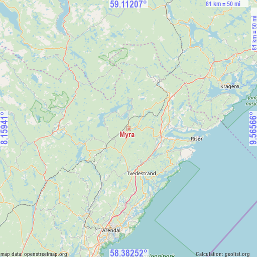
Myra GPS coordinates[2]
58° 44' 57.156" North, 8° 51' 45.144" East
| Map corner | latitude | longitude |
|---|---|---|
| Upper-left | 59.11207°, | 8.15941° |
| Center: | 58.74921°, | 8.86254° |
| Lower-right: | 58.38252°, | 9.56566° |
| Map W x H: | 81.1×81.1 km | = 50.4×50.4mi |
| max Lat: | 71.04137° ⇑92.7% North |
| Myra: | 58.74921° |
| min Lat: | ⇓7.3% South 58.0274° |
| min Long | Myra | max Long |
| 4.71485° | 8.86254° | 31.11066° |
| W 38.9%⇐ | ⇒61.1% E |
Elevation
Elevation of Myra is 176 m = 577 ft, and this is 71.8 m = 236 ft above average elevation for this country.
| Max E: |
897 m = 2943 ft | 19.1% |
| Myra | 176 m 577 ft | |
| Avg. | 104.2 m = 342 ft | |
Min E: |
1 m = 3 ft | 80.9% |
See also: Norway elevation on elevation.city.
Geographical zone
Myra is located in North temperate zone (between Tropic of Cancer and the Arctic Circle). Distance of this North polar circle is 868.9 km =539.9 mi to North.| Distance of | km | miles | from Myra |
|---|---|---|---|
| North Pole | 3474.8 | 2159.1 | to North |
| Arctic Circle | 868.9 | 539.9 | to North |
| Tropic Cancer | 3926.4 | 2439.8 | to South |
| Equator | 6532.3 | 4059 | to South |


Nearby cities:
15 places around Myra: (largest is in red/bold)
• Arendal
32.4 km =20.1 mi,  189°
189°
• Blakstad
29.9 km =18.6 mi,  204°
204°
• Fevik
42.6 km =26.5 mi, 194°
• Gjerstad
17.2 km =10.7 mi,  31°
31°
• Grimstad
48.1 km =29.9 mi, 198°
• Herre
56.2 km =34.9 mi,  45°
45°
• Jordtveit
57 km =35.4 mi, 201°
• Kil
29.8 km =18.5 mi,  57°
57°
• Kragerø
34.5 km =21.4 mi,  67°
67°
• Prestestranda
40.4 km =25.1 mi,  16°
16°
• Risør
21.7 km =13.5 mi,  98°
98°
• Rykene
39.9 km =24.8 mi, 198°
• Treungen
36 km =22.4 mi,  326°
326°
• Tvedestrand
14.7 km =9.1 mi,  164°
164°
• Åmli
21.9 km =13.6 mi,  274°
274°
Sources, notices
• [Note1] Compared only with cities in Norway existing in our database
• [Src1] Map data: © OpenStreetMap contributors (CC-BY-SA)
• [Src2] Other city data from geonames.org with taken over terms of usage.
• [Src3] Geographical zone / Annual Mean Temperature by Robert A. Rohde @ Wikipedia
