Hagavik geodata
Hagavik (Hordaland) is a populated locality; located in Norway in Europe/Oslo (GMT+2) time zone. With population of 1,305 people, there are 257 cities with bigger population in this country. Compared to other cities in Norway, 60.4% of cities are located further ↑North; 91.8% of cities are located further →East and 54.9% of cities have lower elevation than Hagavik. Note1


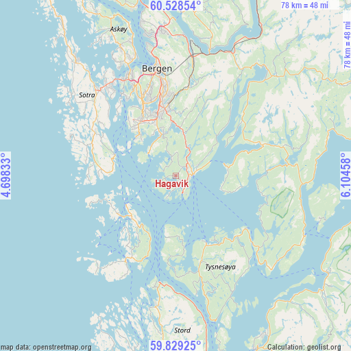
Hagavik GPS coordinates[2]
60° 10' 50.736" North, 5° 24' 5.256" East
| Map corner | latitude | longitude |
|---|---|---|
| Upper-left | 60.52854°, | 4.69833° |
| Center: | 60.18076°, | 5.40146° |
| Lower-right: | 59.82925°, | 6.10458° |
| Map W x H: | 77.8×77.8 km | = 48.3×48.3mi |
| max Lat: | 71.04137° ⇑60.4% North |
| Hagavik: | 60.18076° |
| min Lat: | ⇓39.6% South 58.0274° |
| min Long | Hagavik | max Long |
| 4.71485° | 5.40146° | 31.11066° |
| W 8.2%⇐ | ⇒91.8% E |
Elevation
Elevation of Hagavik is 60 m = 197 ft, and this is 44.2 m = 145 ft below average elevation for this country.
| Max E: |
897 m = 2943 ft | 45.1% |
| Avg. | 104.2 m = 342 ft | |
| Hagavik | 60 m = 197 ft | |
Min E: |
1 m = 3 ft | 54.9% |
See also: Norway elevation on elevation.city.
Geographical zone
Hagavik is located in North temperate zone (between Tropic of Cancer and the Arctic Circle). Distance of this North polar circle is 709.7 km =441 mi to North.| Distance of | km | miles | from Hagavik |
|---|---|---|---|
| North Pole | 3315.6 | 2060.2 | to North |
| Arctic Circle | 709.7 | 441 | to North |
| Tropic Cancer | 4085.6 | 2538.7 | to South |
| Equator | 6691.5 | 4157.9 | to South |


Nearby cities:
15 places around Hagavik: (largest is in red/bold)
• Bergen
24 km =14.9 mi,  349°
349°
• Eikelandsosen
20.1 km =12.5 mi,  70°
70°
• Espeland
22.7 km =14.1 mi,  8°
8°
• Indre Arna
26.6 km =16.5 mi, 8°
• Klokkarvik
14.7 km =9.1 mi,  289°
289°
• Osøyro
3.5 km =2.2 mi,  84°
84°
• Sandsli
15 km =9.3 mi,  334°
334°
• Skogsvågen
18.5 km =11.5 mi,  296°
296°
• Storebø
13.6 km =8.5 mi,  225°
225°
• Straume
25.3 km =15.7 mi,  322°
322°
• Syfteland
7 km =4.3 mi,  24°
24°
• Søvik
4 km =2.5 mi, 348°
• Uggdal
20.9 km =13 mi,  160°
160°
• Våge
16.7 km =10.4 mi, 156°
• Ytrebygda
15.3 km =9.5 mi, 334°
Sources, notices
• [Note1] Compared only with cities in Norway existing in our database
• [Src1] Map data: © OpenStreetMap contributors (CC-BY-SA)
• [Src2] Other city data from geonames.org with taken over terms of usage.
• [Src3] Geographical zone / Annual Mean Temperature by Robert A. Rohde @ Wikipedia
