Sørumsand geodata
Sørumsand (Akershus) is a seat of a second-order administrative division; located in Norway in Europe/Oslo (GMT+2) time zone. With population of 3,563 people, there are 116 cities with bigger population in this country. Compared to other cities in Norway, 64.9% of cities are located further ↑North; 73.4% of cities are located further ←West and 71% of cities have lower elevation than Sørumsand. Note1


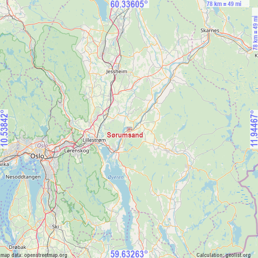
Sørumsand GPS coordinates[2]
59° 59' 10.356" North, 11° 14' 29.544" East
| Map corner | latitude | longitude |
|---|---|---|
| Upper-left | 60.33605°, | 10.53842° |
| Center: | 59.98621°, | 11.24154° |
| Lower-right: | 59.63263°, | 11.94467° |
| Map W x H: | 78.2×78.2 km | = 48.6×48.6mi |
| max Lat: | 71.04137° ⇑64.9% North |
| Sørumsand: | 59.98621° |
| min Lat: | ⇓35.1% South 58.0274° |
| min Long | Sørumsand | max Long |
| 4.71485° | 11.24154° | 31.11066° |
| W 73.4%⇐ | ⇒26.6% E |
Elevation
Elevation of Sørumsand is 127 m = 417 ft, and this is 22.8 m = 75 ft above average elevation for this country.
| Max E: |
897 m = 2943 ft | 29% |
| Sørumsand | 127 m 417 ft | |
| Avg. | 104.2 m = 342 ft | |
Min E: |
1 m = 3 ft | 71% |
See also: Norway elevation on elevation.city.
Geographical zone
Sørumsand is located in North temperate zone (between Tropic of Cancer and the Arctic Circle). Distance of this North polar circle is 731.3 km =454.4 mi to North.| Distance of | km | miles | from Sørumsand |
|---|---|---|---|
| North Pole | 3337.2 | 2073.6 | to North |
| Arctic Circle | 731.3 | 454.4 | to North |
| Tropic Cancer | 4063.9 | 2525.2 | to South |
| Equator | 6669.8 | 4144.4 | to South |


Nearby cities:
15 places around Sørumsand: (largest is in red/bold)
• Ask
14.8 km =9.2 mi,  309°
309°
• Auli
8.5 km =5.3 mi,  50°
50°
• Aursmoen
13 km =8.1 mi,  120°
120°
• Børgen
12.1 km =7.5 mi,  352°
352°
• Fetsund
8.3 km =5.2 mi,  214°
214°
• Fjerdingby
11.9 km =7.4 mi,  235°
235°
• Frogner
8.8 km =5.5 mi,  298°
298°
• Haga
10.5 km =6.5 mi,  44°
44°
• Kløfta
11.3 km =7 mi,  329°
329°
• Leirsund
8.6 km =5.3 mi,  277°
277°
• Lillestrøm
11.2 km =7 mi,  252°
252°
• Lindeberg
8.7 km =5.4 mi, 311°
• Lørenfallet
3.8 km =2.4 mi, 350°
• Neskollen
16 km =9.9 mi,  19°
19°
• Tomteråsen
15.2 km =9.4 mi,  27°
27°
Sources, notices
• [Note1] Compared only with cities in Norway existing in our database
• [Src1] Map data: © OpenStreetMap contributors (CC-BY-SA)
• [Src2] Other city data from geonames.org with taken over terms of usage.
• [Src3] Geographical zone / Annual Mean Temperature by Robert A. Rohde @ Wikipedia
