Haga geodata
Haga (Akershus) is a populated place; located in Norway in Europe/Oslo (GMT+2) time zone. With population of 579 people, there are 430 cities with bigger population in this country. Compared to other cities in Norway, 63.4% of cities are located further ↑North; 76.1% of cities are located further ←West and 73.9% of cities have lower elevation than Haga. Note1


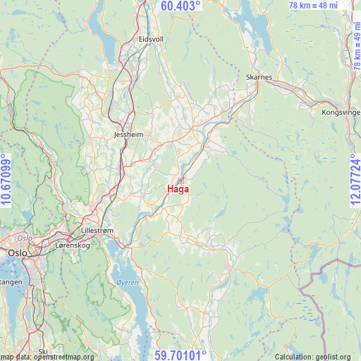
Haga GPS coordinates[2]
60° 3' 13.932" North, 11° 22' 26.796" East
| Map corner | latitude | longitude |
|---|---|---|
| Upper-left | 60.403°, | 10.67099° |
| Center: | 60.05387°, | 11.37411° |
| Lower-right: | 59.70101°, | 12.07724° |
| Map W x H: | 78.1×78.1 km | = 48.5×48.5mi |
| max Lat: | 71.04137° ⇑63.4% North |
| Haga: | 60.05387° |
| min Lat: | ⇓36.6% South 58.0274° |
| min Long | Haga | max Long |
| 4.71485° | 11.37411° | 31.11066° |
| W 76.1%⇐ | ⇒23.9% E |
Elevation
Elevation of Haga is 140 m = 459 ft, and this is 35.8 m = 117 ft above average elevation for this country.
| Max E: |
897 m = 2943 ft | 26.1% |
| Haga | 140 m 459 ft | |
| Avg. | 104.2 m = 342 ft | |
Min E: |
1 m = 3 ft | 73.9% |
See also: Norway elevation on elevation.city.
Geographical zone
Haga is located in North temperate zone (between Tropic of Cancer and the Arctic Circle). Distance of this North polar circle is 723.8 km =449.7 mi to North.| Distance of | km | miles | from Haga |
|---|---|---|---|
| North Pole | 3329.7 | 2069 | to North |
| Arctic Circle | 723.8 | 449.7 | to North |
| Tropic Cancer | 4071.4 | 2529.8 | to South |
| Equator | 6677.4 | 4149.1 | to South |


Nearby cities:
15 places around Haga: (largest is in red/bold)
• Auli
2.3 km =1.4 mi,  199°
199°
• Aursmoen
14.5 km =9 mi,  164°
164°
• Børgen
10 km =6.2 mi,  296°
296°
• Fjellfoten
6.7 km =4.2 mi,  53°
53°
• Frogner
15.4 km =9.6 mi,  257°
257°
• Jessheim
14.7 km =9.1 mi,  311°
311°
• Kløfta
13.3 km =8.3 mi,  279°
279°
• Leirsund
17.1 km =10.6 mi,  248°
248°
• Lindeberg
14 km =8.7 mi, 262°
• Lørenfallet
8.9 km =5.5 mi,  244°
244°
• Neskollen
7.8 km =4.8 mi,  345°
345°
• Nordkisa
15.9 km =9.9 mi,  337°
337°
• Sørumsand
10.5 km =6.5 mi,  224°
224°
• Tomteråsen
5.9 km =3.7 mi,  357°
357°
• Årnes
9.3 km =5.8 mi,  34°
34°
Sources, notices
• [Note1] Compared only with cities in Norway existing in our database
• [Src1] Map data: © OpenStreetMap contributors (CC-BY-SA)
• [Src2] Other city data from geonames.org with taken over terms of usage.
• [Src3] Geographical zone / Annual Mean Temperature by Robert A. Rohde @ Wikipedia
