Lillestrøm geodata
Lillestrøm (Akershus) is a seat of a second-order administrative division; located in Norway in Europe/Oslo (GMT+2) time zone. With population of 14,000 people, there are 35 cities with bigger population in this country. Compared to other cities in Norway, 65.7% of cities are located further ↑North; 68.4% of cities are located further ←West and 68.5% of cities have lower elevation than Lillestrøm. Note1


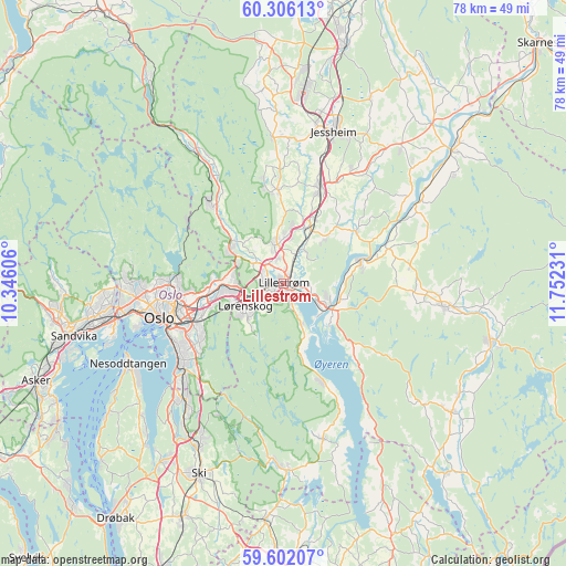
Lillestrøm GPS coordinates[2]
59° 57' 21.492" North, 11° 2' 57.048" East
| Map corner | latitude | longitude |
|---|---|---|
| Upper-left | 60.30613°, | 10.34606° |
| Center: | 59.95597°, | 11.04918° |
| Lower-right: | 59.60207°, | 11.75231° |
| Map W x H: | 78.3×78.3 km | = 48.7×48.7mi |
| max Lat: | 71.04137° ⇑65.7% North |
| Lillestrøm: | 59.95597° |
| min Lat: | ⇓34.3% South 58.0274° |
| min Long | Lillestrøm | max Long |
| 4.71485° | 11.04918° | 31.11066° |
| W 68.4%⇐ | ⇒31.6% E |
Elevation
Elevation of Lillestrøm is 116 m = 381 ft, and this is 11.8 m = 39 ft above average elevation for this country.
| Max E: |
897 m = 2943 ft | 31.5% |
| Lillestrøm | 116 m 381 ft | |
| Avg. | 104.2 m = 342 ft | |
Min E: |
1 m = 3 ft | 68.5% |
See also: Norway elevation on elevation.city.
Geographical zone
Lillestrøm is located in North temperate zone (between Tropic of Cancer and the Arctic Circle). Distance of this North polar circle is 734.7 km =456.5 mi to North.| Distance of | km | miles | from Lillestrøm |
|---|---|---|---|
| North Pole | 3340.6 | 2075.8 | to North |
| Arctic Circle | 734.7 | 456.5 | to North |
| Tropic Cancer | 4060.6 | 2523.1 | to South |
| Equator | 6666.5 | 4142.4 | to South |


Nearby cities:
15 places around Lillestrøm: (largest is in red/bold)
• Ask
12.8 km =8 mi,  356°
356°
• Børgen
17.8 km =11.1 mi,  30°
30°
• Fetsund
6.9 km =4.3 mi,  120°
120°
• Fjerdingby
3.4 km =2.1 mi,  164°
164°
• Flateby
15.2 km =9.4 mi, 157°
• Frogner
8.2 km =5.1 mi,  21°
21°
• Kjenn
6 km =3.7 mi,  242°
242°
• Kløfta
14 km =8.7 mi, 20°
• Leirsund
5 km =3.1 mi, 25°
• Lindeberg
10.1 km =6.3 mi, 24°
• Lørenfallet
12.3 km =7.6 mi,  54°
54°
• Oslo
17.6 km =10.9 mi,  254°
254°
• Rotnes
15.3 km =9.5 mi,  317°
317°
• Sørumsand
11.2 km =7 mi,  72°
72°
• Åneby
17.9 km =11.1 mi,  326°
326°
Sources, notices
• [Note1] Compared only with cities in Norway existing in our database
• [Src1] Map data: © OpenStreetMap contributors (CC-BY-SA)
• [Src2] Other city data from geonames.org with taken over terms of usage.
• [Src3] Geographical zone / Annual Mean Temperature by Robert A. Rohde @ Wikipedia
