Lindeberg geodata
Lindeberg (Akershus) is a populated locality; located in Norway in Europe/Oslo (GMT+2) time zone. With population of 571 people, there are 434 cities with bigger population in this country. Compared to other cities in Norway, 63.9% of cities are located further ↑North; 69.9% of cities are located further ←West and 75.2% of cities have lower elevation than Lindeberg. Note1


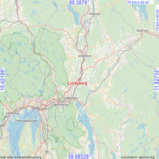
Lindeberg GPS coordinates[2]
60° 2' 17.916" North, 11° 7' 27.156" East
| Map corner | latitude | longitude |
|---|---|---|
| Upper-left | 60.3876°, | 10.42109° |
| Center: | 60.03831°, | 11.12421° |
| Lower-right: | 59.68528°, | 11.82734° |
| Map W x H: | 78.1×78.1 km | = 48.5×48.5mi |
| max Lat: | 71.04137° ⇑63.9% North |
| Lindeberg: | 60.03831° |
| min Lat: | ⇓36.1% South 58.0274° |
| min Long | Lindeberg | max Long |
| 4.71485° | 11.12421° | 31.11066° |
| W 69.9%⇐ | ⇒30.1% E |
Elevation
Elevation of Lindeberg is 143 m = 469 ft, and this is 38.8 m = 127 ft above average elevation for this country.
| Max E: |
897 m = 2943 ft | 24.8% |
| Lindeberg | 143 m 469 ft | |
| Avg. | 104.2 m = 342 ft | |
Min E: |
1 m = 3 ft | 75.2% |
See also: Norway elevation on elevation.city.
Geographical zone
Lindeberg is located in North temperate zone (between Tropic of Cancer and the Arctic Circle). Distance of this North polar circle is 725.5 km =450.8 mi to North.| Distance of | km | miles | from Lindeberg |
|---|---|---|---|
| North Pole | 3331.4 | 2070 | to North |
| Arctic Circle | 725.5 | 450.8 | to North |
| Tropic Cancer | 4069.7 | 2528.8 | to South |
| Equator | 6675.6 | 4148 | to South |


Nearby cities:
15 places around Lindeberg: (largest is in red/bold)
• Ask
6.1 km =3.8 mi,  306°
306°
• Auli
13.1 km =8.1 mi,  91°
91°
• Børgen
7.9 km =4.9 mi,  38°
38°
• Fetsund
12.8 km =8 mi,  171°
171°
• Fjerdingby
12.9 km =8 mi,  194°
194°
• Frogner
1.9 km =1.2 mi,  217°
217°
• Haga
14 km =8.7 mi,  82°
82°
• Jessheim
11.8 km =7.3 mi,  13°
13°
• Kløfta
4 km =2.5 mi, 10°
• Leirsund
5 km =3.1 mi,  203°
203°
• Lillestrøm
10.1 km =6.3 mi, 204°
• Lørenfallet
6.2 km =3.9 mi,  109°
109°
• Neskollen
15.1 km =9.4 mi,  52°
52°
• Rotnes
14.7 km =9.1 mi,  278°
278°
• Sørumsand
8.7 km =5.4 mi,  131°
131°
Sources, notices
• [Note1] Compared only with cities in Norway existing in our database
• [Src1] Map data: © OpenStreetMap contributors (CC-BY-SA)
• [Src2] Other city data from geonames.org with taken over terms of usage.
• [Src3] Geographical zone / Annual Mean Temperature by Robert A. Rohde @ Wikipedia
