Lørenfallet geodata
Lørenfallet (Akershus) is a populated place; located in Norway in Europe/Oslo (GMT+2) time zone. With population of 926 people, there are 328 cities with bigger population in this country. Compared to other cities in Norway, 64.4% of cities are located further ↑North; 73.1% of cities are located further ←West and 70.4% of cities have lower elevation than Lørenfallet. Note1


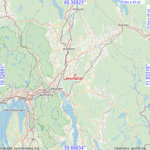
Lørenfallet GPS coordinates[2]
60° 1' 11.136" North, 11° 13' 48.108" East
| Map corner | latitude | longitude |
|---|---|---|
| Upper-left | 60.36925°, | 10.52691° |
| Center: | 60.01976°, | 11.23003° |
| Lower-right: | 59.66654°, | 11.93316° |
| Map W x H: | 78.1×78.1 km | = 48.5×48.5mi |
| max Lat: | 71.04137° ⇑64.4% North |
| Lørenfallet: | 60.01976° |
| min Lat: | ⇓35.6% South 58.0274° |
| min Long | Lørenfallet | max Long |
| 4.71485° | 11.23003° | 31.11066° |
| W 73.1%⇐ | ⇒26.9% E |
Elevation
Elevation of Lørenfallet is 122 m = 400 ft, and this is 17.8 m = 58 ft above average elevation for this country.
| Max E: |
897 m = 2943 ft | 29.6% |
| Lørenfallet | 122 m 400 ft | |
| Avg. | 104.2 m = 342 ft | |
Min E: |
1 m = 3 ft | 70.4% |
See also: Norway elevation on elevation.city.
Geographical zone
Lørenfallet is located in North temperate zone (between Tropic of Cancer and the Arctic Circle). Distance of this North polar circle is 727.6 km =452.1 mi to North.| Distance of | km | miles | from Lørenfallet |
|---|---|---|---|
| North Pole | 3333.5 | 2071.3 | to North |
| Arctic Circle | 727.6 | 452.1 | to North |
| Tropic Cancer | 4067.7 | 2527.6 | to South |
| Equator | 6673.6 | 4146.8 | to South |


Nearby cities:
15 places around Lørenfallet: (largest is in red/bold)
• Ask
12.2 km =7.6 mi,  298°
298°
• Auli
7.4 km =4.6 mi,  77°
77°
• Børgen
8.3 km =5.2 mi,  353°
353°
• Fetsund
11.3 km =7 mi,  200°
200°
• Fjerdingby
13.9 km =8.6 mi,  221°
221°
• Frogner
7.1 km =4.4 mi,  274°
274°
• Haga
8.9 km =5.5 mi,  64°
64°
• Jessheim
13.9 km =8.6 mi, 347°
• Kløfta
7.9 km =4.9 mi,  319°
319°
• Leirsund
8.3 km =5.2 mi,  252°
252°
• Lillestrøm
12.3 km =7.6 mi,  234°
234°
• Lindeberg
6.2 km =3.9 mi,  289°
289°
• Neskollen
12.8 km =8 mi,  28°
28°
• Sørumsand
3.8 km =2.4 mi,  170°
170°
• Tomteråsen
12.4 km =7.7 mi,  38°
38°
Sources, notices
• [Note1] Compared only with cities in Norway existing in our database
• [Src1] Map data: © OpenStreetMap contributors (CC-BY-SA)
• [Src2] Other city data from geonames.org with taken over terms of usage.
• [Src3] Geographical zone / Annual Mean Temperature by Robert A. Rohde @ Wikipedia
