Frogner geodata
Frogner (Akershus) is a populated place; located in Norway in Europe/Oslo (GMT+2) time zone. With population of 1,108 people, there are 293 cities with bigger population in this country. Compared to other cities in Norway, 64.2% of cities are located further ↑North; 69.5% of cities are located further ←West and 73.4% of cities have lower elevation than Frogner. Note1


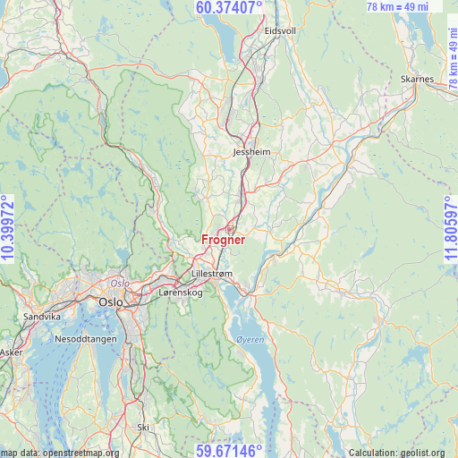
Frogner GPS coordinates[2]
60° 1' 28.668" North, 11° 6' 10.224" East
| Map corner | latitude | longitude |
|---|---|---|
| Upper-left | 60.37407°, | 10.39972° |
| Center: | 60.02463°, | 11.10284° |
| Lower-right: | 59.67146°, | 11.80597° |
| Map W x H: | 78.1×78.1 km | = 48.5×48.5mi |
| max Lat: | 71.04137° ⇑64.2% North |
| Frogner: | 60.02463° |
| min Lat: | ⇓35.8% South 58.0274° |
| min Long | Frogner | max Long |
| 4.71485° | 11.10284° | 31.11066° |
| W 69.5%⇐ | ⇒30.5% E |
Elevation
Elevation of Frogner is 138 m = 453 ft, and this is 33.8 m = 111 ft above average elevation for this country.
| Max E: |
897 m = 2943 ft | 26.6% |
| Frogner | 138 m 453 ft | |
| Avg. | 104.2 m = 342 ft | |
Min E: |
1 m = 3 ft | 73.4% |
See also: Norway elevation on elevation.city.
Geographical zone
Frogner is located in North temperate zone (between Tropic of Cancer and the Arctic Circle). Distance of this North polar circle is 727.1 km =451.8 mi to North.| Distance of | km | miles | from Frogner |
|---|---|---|---|
| North Pole | 3332.9 | 2071 | to North |
| Arctic Circle | 727.1 | 451.8 | to North |
| Tropic Cancer | 4068.2 | 2527.9 | to South |
| Equator | 6674.1 | 4147.1 | to South |


Nearby cities:
15 places around Frogner: (largest is in red/bold)
• Ask
6.4 km =4 mi,  324°
324°
• Auli
14.4 km =8.9 mi,  85°
85°
• Børgen
9.8 km =6.1 mi,  38°
38°
• Fetsund
11.5 km =7.1 mi,  164°
164°
• Fjerdingby
11.1 km =6.9 mi,  190°
190°
• Jessheim
13.6 km =8.5 mi,  17°
17°
• Kjenn
13.3 km =8.3 mi,  218°
218°
• Kløfta
5.8 km =3.6 mi, 19°
• Leirsund
3.2 km =2 mi,  195°
195°
• Lillestrøm
8.2 km =5.1 mi, 201°
• Lindeberg
1.9 km =1.2 mi, 37°
• Lørenfallet
7.1 km =4.4 mi, 94°
• Rotnes
13.9 km =8.6 mi,  285°
285°
• Sørumsand
8.8 km =5.5 mi,  118°
118°
• Åneby
14.8 km =9.2 mi,  299°
299°
Sources, notices
• [Note1] Compared only with cities in Norway existing in our database
• [Src1] Map data: © OpenStreetMap contributors (CC-BY-SA)
• [Src2] Other city data from geonames.org with taken over terms of usage.
• [Src3] Geographical zone / Annual Mean Temperature by Robert A. Rohde @ Wikipedia
