Aursmoen geodata
Aursmoen (Akershus) is a populated place; located in Norway in Europe/Oslo (GMT+2) time zone. With population of 2,173 people, there are 180 cities with bigger population in this country. Compared to other cities in Norway, 66.5% of cities are located further ↑North; 76.9% of cities are located further ←West and 81.2% of cities have lower elevation than Aursmoen. Note1


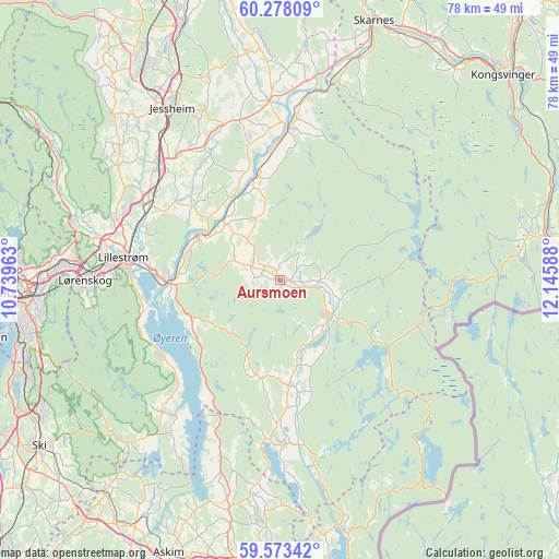
Aursmoen GPS coordinates[2]
59° 55' 39.468" North, 11° 26' 33.9" East
| Map corner | latitude | longitude |
|---|---|---|
| Upper-left | 60.27809°, | 10.73963° |
| Center: | 59.92763°, | 11.44275° |
| Lower-right: | 59.57342°, | 12.14588° |
| Map W x H: | 78.4×78.3 km | = 48.7×48.7mi |
| max Lat: | 71.04137° ⇑66.5% North |
| Aursmoen: | 59.92763° |
| min Lat: | ⇓33.5% South 58.0274° |
| min Long | Aursmoen | max Long |
| 4.71485° | 11.44275° | 31.11066° |
| W 76.9%⇐ | ⇒23.1% E |
Elevation
Elevation of Aursmoen is 180 m = 591 ft, and this is 75.8 m = 249 ft above average elevation for this country.
| Max E: |
897 m = 2943 ft | 18.8% |
| Aursmoen | 180 m 591 ft | |
| Avg. | 104.2 m = 342 ft | |
Min E: |
1 m = 3 ft | 81.2% |
See also: Norway elevation on elevation.city.
Geographical zone
Aursmoen is located in North temperate zone (between Tropic of Cancer and the Arctic Circle). Distance of this North polar circle is 737.8 km =458.4 mi to North.| Distance of | km | miles | from Aursmoen |
|---|---|---|---|
| North Pole | 3343.7 | 2077.7 | to North |
| Arctic Circle | 737.8 | 458.4 | to North |
| Tropic Cancer | 4057.4 | 2521.2 | to South |
| Equator | 6663.3 | 4140.4 | to South |


Nearby cities:
15 places around Aursmoen: (largest is in red/bold)
• Auli
12.7 km =7.9 mi,  338°
338°
• Bjørkelangen
8.3 km =5.2 mi,  125°
125°
• Fetsund
15.9 km =9.9 mi,  268°
268°
• Fjellfoten
18.1 km =11.2 mi,  5°
5°
• Fjerdingby
21 km =13 mi, 269°
• Flateby
19.5 km =12.1 mi,  235°
235°
• Fosser
12.2 km =7.6 mi,  168°
168°
• Haga
14.5 km =9 mi, 344°
• Leirsund
21.2 km =13.2 mi,  291°
291°
• Lindeberg
21.6 km =13.4 mi,  304°
304°
• Løken
14.7 km =9.1 mi, 174°
• Lørenfallet
15.7 km =9.8 mi,  310°
310°
• Sørumsand
13 km =8.1 mi, 300°
• Tomteråsen
20.4 km =12.7 mi,  348°
348°
• Årnes
21.7 km =13.5 mi,  4°
4°
Sources, notices
• [Note1] Compared only with cities in Norway existing in our database
• [Src1] Map data: © OpenStreetMap contributors (CC-BY-SA)
• [Src2] Other city data from geonames.org with taken over terms of usage.
• [Src3] Geographical zone / Annual Mean Temperature by Robert A. Rohde @ Wikipedia
