Skreia geodata
Skreia (Oppland) is a populated place; located in Norway in Europe/Oslo (GMT+2) time zone. With population of 1,285 people, there are 258 cities with bigger population in this country. Compared to other cities in Norway, 50.6% of cities are located further ↓South; 66.3% of cities are located further ←West and 73.9% of cities have lower elevation than Skreia. Note1


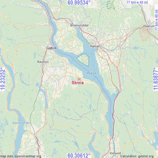
Skreia GPS coordinates[2]
60° 39' 9.252" North, 10° 56' 8.304" East
| Map corner | latitude | longitude |
|---|---|---|
| Upper-left | 60.99534°, | 10.23252° |
| Center: | 60.65257°, | 10.93564° |
| Lower-right: | 60.30612°, | 11.63877° |
| Map W x H: | 76.6×76.6 km | = 47.6×47.6mi |
| max Lat: | 71.04137° ⇑49.4% North |
| Skreia: | 60.65257° |
| min Lat: | ⇓50.6% South 58.0274° |
| min Long | Skreia | max Long |
| 4.71485° | 10.93564° | 31.11066° |
| W 66.3%⇐ | ⇒33.7% E |
Elevation
Elevation of Skreia is 140 m = 459 ft, and this is 35.8 m = 117 ft above average elevation for this country.
| Max E: |
897 m = 2943 ft | 26.1% |
| Skreia | 140 m 459 ft | |
| Avg. | 104.2 m = 342 ft | |
Min E: |
1 m = 3 ft | 73.9% |
See also: Norway elevation on elevation.city.
Geographical zone
Skreia is located in North temperate zone (between Tropic of Cancer and the Arctic Circle). Distance of this North polar circle is 657.2 km =408.4 mi to North.| Distance of | km | miles | from Skreia |
|---|---|---|---|
| North Pole | 3263.1 | 2027.6 | to North |
| Arctic Circle | 657.2 | 408.4 | to North |
| Tropic Cancer | 4138 | 2571.2 | to South |
| Equator | 6743.9 | 4190.5 | to South |


Nearby cities:
15 places around Skreia: (largest is in red/bold)
• Brumunddal
25.4 km =15.8 mi,  0°
0°
• Eina
18.6 km =11.6 mi,  261°
261°
• Gjøvik
20.7 km =12.9 mi,  320°
320°
• Hamar
17.3 km =10.7 mi,  24°
24°
• Hov
32.2 km =20 mi,  279°
279°
• Hurdal
25.2 km =15.7 mi,  163°
163°
• Ilseng
21 km =13 mi,  49°
49°
• Kolbu
10.4 km =6.5 mi,  268°
268°
• Lena
7.1 km =4.4 mi,  289°
289°
• Løten
28.8 km =17.9 mi, 49°
• Moelv
33.7 km =20.9 mi,  337°
337°
• Raufoss
19.4 km =12.1 mi, 294°
• Reinsvoll
17.4 km =10.8 mi, 280°
• Stange
15.8 km =9.8 mi,  62°
62°
• Ådalsbruk
25.8 km =16 mi, 51°
Sources, notices
• [Note1] Compared only with cities in Norway existing in our database
• [Src1] Map data: © OpenStreetMap contributors (CC-BY-SA)
• [Src2] Other city data from geonames.org with taken over terms of usage.
• [Src3] Geographical zone / Annual Mean Temperature by Robert A. Rohde @ Wikipedia
