Moelv geodata
Moelv (Hedmark) is a populated place; located in Norway in Europe/Oslo (GMT+2) time zone. With population of 4,049 people, there are 107 cities with bigger population in this country. Compared to other cities in Norway, 55.1% of cities are located further ↓South; 62.5% of cities are located further ←West and 81.2% of cities have lower elevation than Moelv. Note1


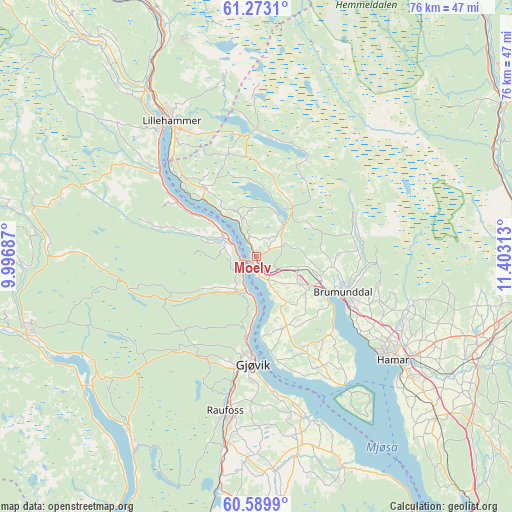
Moelv GPS coordinates[2]
60° 55' 59.988" North, 10° 42' 0" East
| Map corner | latitude | longitude |
|---|---|---|
| Upper-left | 61.2731°, | 9.99687° |
| Center: | 60.93333°, | 10.7° |
| Lower-right: | 60.5899°, | 11.40313° |
| Map W x H: | 76×76 km | = 47.2×47.2mi |
| max Lat: | 71.04137° ⇑44.9% North |
| Moelv: | 60.93333° |
| min Lat: | ⇓55.1% South 58.0274° |
| min Long | Moelv | max Long |
| 4.71485° | 10.7° | 31.11066° |
| W 62.5%⇐ | ⇒37.5% E |
Elevation
Elevation of Moelv is 180 m = 591 ft, and this is 75.8 m = 249 ft above average elevation for this country.
| Max E: |
897 m = 2943 ft | 18.8% |
| Moelv | 180 m 591 ft | |
| Avg. | 104.2 m = 342 ft | |
Min E: |
1 m = 3 ft | 81.2% |
See also: Norway elevation on elevation.city.
Geographical zone
Moelv is located in North temperate zone (between Tropic of Cancer and the Arctic Circle). Distance of this North polar circle is 626 km =389 mi to North.| Distance of | km | miles | from Moelv |
|---|---|---|---|
| North Pole | 3231.9 | 2008.2 | to North |
| Arctic Circle | 626 | 389 | to North |
| Tropic Cancer | 4169.2 | 2590.6 | to South |
| Equator | 6775.2 | 4209.9 | to South |


Nearby cities:
15 places around Moelv: (largest is in red/bold)
• Brumunddal
14.2 km =8.8 mi,  114°
114°
• Dokka
35.6 km =22.1 mi,  252°
252°
• Eina
34.3 km =21.3 mi,  189°
189°
• Gjøvik
15.3 km =9.5 mi,  181°
181°
• Hamar
25.2 km =15.7 mi,  127°
127°
• Hov
32.2 km =20 mi,  215°
215°
• Ilseng
33.5 km =20.8 mi,  121°
121°
• Kolbu
31.6 km =19.6 mi, 175°
• Lena
29.5 km =18.3 mi,  167°
167°
• Lillehammer
23.8 km =14.8 mi,  328°
328°
• Raufoss
23.5 km =14.6 mi, 191°
• Reinsvoll
28.5 km =17.7 mi, 188°
• Skreia
33.7 km =20.9 mi,  157°
157°
• Stange
35.9 km =22.3 mi, 131°
• Ådalsbruk
36.3 km =22.6 mi, 114°
Sources, notices
• [Note1] Compared only with cities in Norway existing in our database
• [Src1] Map data: © OpenStreetMap contributors (CC-BY-SA)
• [Src2] Other city data from geonames.org with taken over terms of usage.
• [Src3] Geographical zone / Annual Mean Temperature by Robert A. Rohde @ Wikipedia
