Eina geodata
Eina (Oppland) is a populated place; located in Norway in Europe/Oslo (GMT+2) time zone. With population of 657 people, there are 393 cities with bigger population in this country. Compared to other cities in Norway, 50.2% of cities are located further ↑North; 60% of cities are located further ←West and 94.5% of cities have lower elevation than Eina. Note1


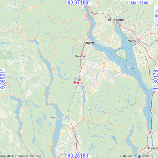
Eina GPS coordinates[2]
60° 37' 43.104" North, 10° 35' 55.068" East
| Map corner | latitude | longitude |
|---|---|---|
| Upper-left | 60.97166°, | 9.89551° |
| Center: | 60.62864°, | 10.59863° |
| Lower-right: | 60.28193°, | 11.30176° |
| Map W x H: | 76.7×76.7 km | = 47.7×47.7mi |
| max Lat: | 71.04137° ⇑50.2% North |
| Eina: | 60.62864° |
| min Lat: | ⇓49.8% South 58.0274° |
| min Long | Eina | max Long |
| 4.71485° | 10.59863° | 31.11066° |
| W 60%⇐ | ⇒40% E |
Elevation
Elevation of Eina is 409 m = 1342 ft, and this is 304.8 m = 1000 ft above average elevation for this country.
| Max E: |
897 m = 2943 ft | 5.5% |
| Eina | 409 m 1342 ft | |
| Avg. | 104.2 m = 342 ft | |
Min E: |
1 m = 3 ft | 94.5% |
See also: Norway elevation on elevation.city.
Geographical zone
Eina is located in North temperate zone (between Tropic of Cancer and the Arctic Circle). Distance of this North polar circle is 659.9 km =410 mi to North.| Distance of | km | miles | from Eina |
|---|---|---|---|
| North Pole | 3265.8 | 2029.3 | to North |
| Arctic Circle | 659.9 | 410 | to North |
| Tropic Cancer | 4135.4 | 2569.6 | to South |
| Equator | 6741.3 | 4188.8 | to South |


Nearby cities:
15 places around Eina: (largest is in red/bold)
• Brumunddal
33.6 km =20.9 mi,  33°
33°
• Dokka
36.6 km =22.7 mi,  308°
308°
• Gjøvik
19.3 km =12 mi,  15°
15°
• Hamar
31.5 km =19.6 mi,  54°
54°
• Hov
15.5 km =9.6 mi,  300°
300°
• Hurdal
33.5 km =20.8 mi,  130°
130°
• Jaren
26.3 km =16.3 mi,  184°
184°
• Kolbu
8.3 km =5.2 mi,  73°
73°
• Lena
12.7 km =7.9 mi, 66°
• Moelv
34.3 km =21.3 mi,  9°
9°
• Raufoss
10.9 km =6.8 mi,  4°
4°
• Reinsvoll
5.8 km =3.6 mi, 12°
• Roa
37.6 km =23.4 mi, 178°
• Skreia
18.6 km =11.6 mi,  81°
81°
• Stange
33.9 km =21.1 mi, 72°
Sources, notices
• [Note1] Compared only with cities in Norway existing in our database
• [Src1] Map data: © OpenStreetMap contributors (CC-BY-SA)
• [Src2] Other city data from geonames.org with taken over terms of usage.
• [Src3] Geographical zone / Annual Mean Temperature by Robert A. Rohde @ Wikipedia
