Rykene geodata
Rykene (Aust-Agder) is a populated place; located in Norway in Europe/Oslo (GMT+2) time zone. With population of 647 people, there are 399 cities with bigger population in this country. Compared to other cities in Norway, 95.7% of cities are located further ↑North; 62.2% of cities are located further →East and 53.3% of cities have higher elevation than Rykene. Note1


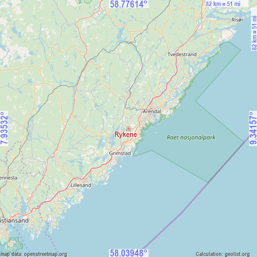
Rykene GPS coordinates[2]
58° 24' 35.064" North, 8° 38' 18.384" East
| Map corner | latitude | longitude |
|---|---|---|
| Upper-left | 58.77614°, | 7.93532° |
| Center: | 58.40974°, | 8.63844° |
| Lower-right: | 58.03948°, | 9.34157° |
| Map W x H: | 81.9×81.9 km | = 50.9×50.9mi |
| max Lat: | 71.04137° ⇑95.7% North |
| Rykene: | 58.40974° |
| min Lat: | ⇓4.3% South 58.0274° |
| min Long | Rykene | max Long |
| 4.71485° | 8.63844° | 31.11066° |
| W 37.8%⇐ | ⇒62.2% E |
Elevation
Elevation of Rykene is 38 m = 125 ft, and this is 66.2 m = 217 ft below average elevation for this country.
| Max E: |
897 m = 2943 ft | 53.3% |
| Avg. | 104.2 m = 342 ft | |
| Rykene | 38 m = 125 ft | |
Min E: |
1 m = 3 ft | 46.7% |
See also: Norway elevation on elevation.city.
Geographical zone
Rykene is located in North temperate zone (between Tropic of Cancer and the Arctic Circle). Distance of this North polar circle is 906.6 km =563.3 mi to North.| Distance of | km | miles | from Rykene |
|---|---|---|---|
| North Pole | 3512.5 | 2182.6 | to North |
| Arctic Circle | 906.6 | 563.3 | to North |
| Tropic Cancer | 3888.6 | 2416.3 | to South |
| Equator | 6494.6 | 4035.6 | to South |


Nearby cities:
15 places around Rykene: (largest is in red/bold)
• Arendal
9.7 km =6 mi,  53°
53°
• Birkeland
25.3 km =15.7 mi,  249°
249°
• Birketveit
42.4 km =26.3 mi,  277°
277°
• Blakstad
10.6 km =6.6 mi,  2°
2°
• Fevik
4.1 km =2.5 mi,  148°
148°
• Grimstad
8.1 km =5 mi,  198°
198°
• Jordtveit
17.1 km =10.6 mi,  206°
206°
• Justvik
42.7 km =26.5 mi,  236°
236°
• Kristiansand
47.6 km =29.6 mi,  232°
232°
• Lillesand
23.5 km =14.6 mi,  220°
220°
• Myra
39.9 km =24.8 mi,  18°
18°
• Tvedestrand
29.1 km =18.1 mi,  35°
35°
• Tveit
36 km =22.4 mi, 237°
• Vennesla
41.9 km =26 mi, 247°
• Åmli
40.6 km =25.2 mi,  347°
347°
Sources, notices
• [Note1] Compared only with cities in Norway existing in our database
• [Src1] Map data: © OpenStreetMap contributors (CC-BY-SA)
• [Src2] Other city data from geonames.org with taken over terms of usage.
• [Src3] Geographical zone / Annual Mean Temperature by Robert A. Rohde @ Wikipedia
