Grimstad geodata
Grimstad (Aust-Agder) is a seat of a second-order administrative division; located in Norway in Europe/Oslo (GMT+2) time zone. With population of 9,561 people, there are 50 cities with bigger population in this country. Compared to other cities in Norway, 96.4% of cities are located further ↑North; 62.7% of cities are located further →East and 82.9% of cities have higher elevation than Grimstad. Note1


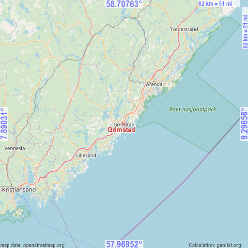
Grimstad GPS coordinates[2]
58° 20' 25.8" North, 8° 35' 36.348" East
| Map corner | latitude | longitude |
|---|---|---|
| Upper-left | 58.70763°, | 7.89031° |
| Center: | 58.3405°, | 8.59343° |
| Lower-right: | 57.96952°, | 9.29656° |
| Map W x H: | 82.1×82.1 km | = 51×51mi |
| max Lat: | 71.04137° ⇑96.4% North |
| Grimstad: | 58.3405° |
| min Lat: | ⇓3.6% South 58.0274° |
| min Long | Grimstad | max Long |
| 4.71485° | 8.59343° | 31.11066° |
| W 37.3%⇐ | ⇒62.7% E |
Elevation
Elevation of Grimstad is 9 m = 30 ft, and this is 95.2 m = 312 ft below average elevation for this country.
| Max E: |
897 m = 2943 ft | 82.9% |
| Avg. | 104.2 m = 342 ft | |
| Grimstad | 9 m = 30 ft | |
Min E: |
1 m = 3 ft | 17.1% |
See also: Norway elevation on elevation.city.
Geographical zone
Grimstad is located in North temperate zone (between Tropic of Cancer and the Arctic Circle). Distance of this North polar circle is 914.3 km =568.1 mi to North.| Distance of | km | miles | from Grimstad |
|---|---|---|---|
| North Pole | 3520.2 | 2187.4 | to North |
| Arctic Circle | 914.3 | 568.1 | to North |
| Tropic Cancer | 3880.9 | 2411.5 | to South |
| Equator | 6486.9 | 4030.8 | to South |


Nearby cities:
15 places around Grimstad: (largest is in red/bold)
• Arendal
17 km =10.6 mi,  37°
37°
• Birkeland
21.1 km =13.1 mi,  267°
267°
• Birketveit
41.6 km =25.8 mi,  288°
288°
• Blakstad
18.5 km =11.5 mi,  9°
9°
• Fevik
6.4 km =4 mi,  48°
48°
• Jordtveit
9.2 km =5.7 mi,  213°
213°
• Justvik
36.6 km =22.7 mi,  244°
244°
• Kristiansand
41.1 km =25.5 mi, 238°
• Lillesand
16.2 km =10.1 mi,  231°
231°
• Rykene
8.1 km =5 mi,  18°
18°
• Skålevik
44.6 km =27.7 mi, 229°
• Strai
42.4 km =26.3 mi,  246°
246°
• Tvedestrand
37 km =23 mi,  32°
32°
• Tveit
30 km =18.6 mi, 246°
• Vennesla
37.1 km =23.1 mi,  257°
257°
Sources, notices
• [Note1] Compared only with cities in Norway existing in our database
• [Src1] Map data: © OpenStreetMap contributors (CC-BY-SA)
• [Src2] Other city data from geonames.org with taken over terms of usage.
• [Src3] Geographical zone / Annual Mean Temperature by Robert A. Rohde @ Wikipedia
