Nordkisa geodata
Nordkisa (Akershus) is a populated place; located in Norway in Europe/Oslo (GMT+2) time zone. With population of 853 people, there are 347 cities with bigger population in this country. Compared to other cities in Norway, 60% of cities are located further ↑North; 73.7% of cities are located further ←West and 83.5% of cities have lower elevation than Nordkisa. Note1


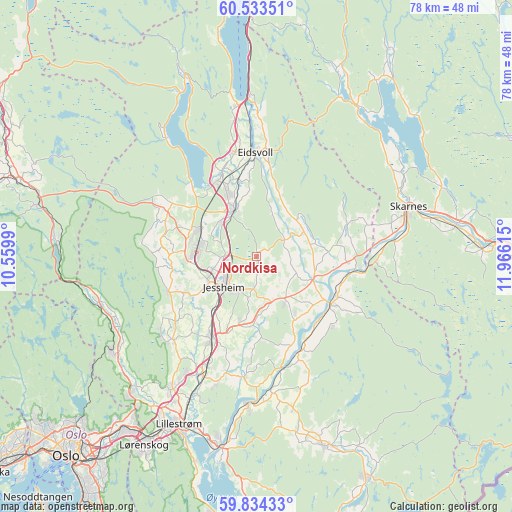
Nordkisa GPS coordinates[2]
60° 11' 8.808" North, 11° 15' 46.872" East
| Map corner | latitude | longitude |
|---|---|---|
| Upper-left | 60.53351°, | 10.5599° |
| Center: | 60.18578°, | 11.26302° |
| Lower-right: | 59.83433°, | 11.96615° |
| Map W x H: | 77.7×77.7 km | = 48.3×48.3mi |
| max Lat: | 71.04137° ⇑60% North |
| Nordkisa: | 60.18578° |
| min Lat: | ⇓40% South 58.0274° |
| min Long | Nordkisa | max Long |
| 4.71485° | 11.26302° | 31.11066° |
| W 73.7%⇐ | ⇒26.3% E |
Elevation
Elevation of Nordkisa is 200 m = 656 ft, and this is 95.8 m = 314 ft above average elevation for this country.
| Max E: |
897 m = 2943 ft | 16.5% |
| Nordkisa | 200 m 656 ft | |
| Avg. | 104.2 m = 342 ft | |
Min E: |
1 m = 3 ft | 83.5% |
See also: Norway elevation on elevation.city.
Geographical zone
Nordkisa is located in North temperate zone (between Tropic of Cancer and the Arctic Circle). Distance of this North polar circle is 709.1 km =440.6 mi to North.| Distance of | km | miles | from Nordkisa |
|---|---|---|---|
| North Pole | 3315 | 2059.8 | to North |
| Arctic Circle | 709.1 | 440.6 | to North |
| Tropic Cancer | 4086.1 | 2539 | to South |
| Equator | 6692 | 4158.2 | to South |


Nearby cities:
15 places around Nordkisa: (largest is in red/bold)
• Ask
17.9 km =11.1 mi,  224°
224°
• Auli
17.7 km =11 mi,  162°
162°
• Børgen
10.6 km =6.6 mi,  195°
195°
• Eidsvoll
16.2 km =10.1 mi,  359°
359°
• Fjellfoten
15.8 km =9.8 mi,  132°
132°
• Haga
15.9 km =9.9 mi, 157°
• Jessheim
6.9 km =4.3 mi, 224°
• Kløfta
14.2 km =8.8 mi,  209°
209°
• Maura
15.1 km =9.4 mi,  302°
302°
• Neskollen
8.3 km =5.2 mi,  149°
149°
• Råholt
11 km =6.8 mi,  334°
334°
• Sesvoll
8.9 km =5.5 mi,  323°
323°
• Teigebyen
14.1 km =8.8 mi,  285°
285°
• Tomteråsen
10.5 km =6.5 mi, 146°
• Årnes
13.5 km =8.4 mi,  121°
121°
Sources, notices
• [Note1] Compared only with cities in Norway existing in our database
• [Src1] Map data: © OpenStreetMap contributors (CC-BY-SA)
• [Src2] Other city data from geonames.org with taken over terms of usage.
• [Src3] Geographical zone / Annual Mean Temperature by Robert A. Rohde @ Wikipedia
