Råholt geodata
Råholt (Akershus) is a populated place; located in Norway in Europe/Oslo (GMT+2) time zone. With population of 8,593 people, there are 54 cities with bigger population in this country. Compared to other cities in Norway, 57.3% of cities are located further ↑North; 71.4% of cities are located further ←West and 80.5% of cities have lower elevation than Råholt. Note1


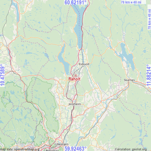
Råholt GPS coordinates[2]
60° 16' 30.468" North, 11° 10' 44.436" East
| Map corner | latitude | longitude |
|---|---|---|
| Upper-left | 60.62191°, | 10.47589° |
| Center: | 60.27513°, | 11.17901° |
| Lower-right: | 59.92463°, | 11.88214° |
| Map W x H: | 77.5×77.5 km | = 48.2×48.2mi |
| max Lat: | 71.04137° ⇑57.3% North |
| Råholt: | 60.27513° |
| min Lat: | ⇓42.7% South 58.0274° |
| min Long | Råholt | max Long |
| 4.71485° | 11.17901° | 31.11066° |
| W 71.4%⇐ | ⇒28.6% E |
Elevation
Elevation of Råholt is 174 m = 571 ft, and this is 69.8 m = 229 ft above average elevation for this country.
| Max E: |
897 m = 2943 ft | 19.5% |
| Råholt | 174 m 571 ft | |
| Avg. | 104.2 m = 342 ft | |
Min E: |
1 m = 3 ft | 80.5% |
See also: Norway elevation on elevation.city.
Geographical zone
Råholt is located in North temperate zone (between Tropic of Cancer and the Arctic Circle). Distance of this North polar circle is 699.2 km =434.5 mi to North.| Distance of | km | miles | from Råholt |
|---|---|---|---|
| North Pole | 3305.1 | 2053.7 | to North |
| Arctic Circle | 699.2 | 434.5 | to North |
| Tropic Cancer | 4096 | 2545.1 | to South |
| Equator | 6702 | 4164.4 | to South |


Nearby cities:
15 places around Råholt: (largest is in red/bold)
• Ask
24 km =14.9 mi,  199°
199°
• Børgen
20.2 km =12.6 mi,  174°
174°
• Eidsvoll
7.7 km =4.8 mi,  36°
36°
• Fjellfoten
26.2 km =16.3 mi,  141°
141°
• Hurdal
18.8 km =11.7 mi,  340°
340°
• Jessheim
14.9 km =9.3 mi,  180°
180°
• Kløfta
22.5 km =14 mi,  185°
185°
• Maura
8.3 km =5.2 mi,  257°
257°
• Neskollen
19.2 km =11.9 mi,  152°
152°
• Nordkisa
11 km =6.8 mi, 154°
• Sand
23.8 km =14.8 mi,  56°
56°
• Sesvoll
2.9 km =1.8 mi, 193°
• Teigebyen
10.8 km =6.7 mi,  235°
235°
• Tomteråsen
21.4 km =13.3 mi, 150°
• Årnes
23.4 km =14.5 mi, 136°
Sources, notices
• [Note1] Compared only with cities in Norway existing in our database
• [Src1] Map data: © OpenStreetMap contributors (CC-BY-SA)
• [Src2] Other city data from geonames.org with taken over terms of usage.
• [Src3] Geographical zone / Annual Mean Temperature by Robert A. Rohde @ Wikipedia
