Årnes geodata
Årnes (Akershus) is a seat of a second-order administrative division; located in Norway in Europe/Oslo (GMT+2) time zone. With population of 3,289 people, there are 122 cities with bigger population in this country. Compared to other cities in Norway, 61.1% of cities are located further ↑North; 77.4% of cities are located further ←West and 73.9% of cities have lower elevation than Årnes. Note1


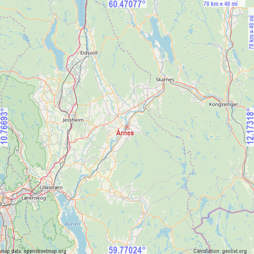
Årnes GPS coordinates[2]
60° 7' 20.532" North, 11° 28' 12.18" East
| Map corner | latitude | longitude |
|---|---|---|
| Upper-left | 60.47077°, | 10.76693° |
| Center: | 60.12237°, | 11.47005° |
| Lower-right: | 59.77024°, | 12.17318° |
| Map W x H: | 77.9×77.9 km | = 48.4×48.4mi |
| max Lat: | 71.04137° ⇑61.1% North |
| Årnes: | 60.12237° |
| min Lat: | ⇓38.9% South 58.0274° |
| min Long | Årnes | max Long |
| 4.71485° | 11.47005° | 31.11066° |
| W 77.4%⇐ | ⇒22.6% E |
Elevation
Elevation of Årnes is 140 m = 459 ft, and this is 35.8 m = 117 ft above average elevation for this country.
| Max E: |
897 m = 2943 ft | 26.1% |
| Årnes | 140 m 459 ft | |
| Avg. | 104.2 m = 342 ft | |
Min E: |
1 m = 3 ft | 73.9% |
See also: Norway elevation on elevation.city.
Geographical zone
Årnes is located in North temperate zone (between Tropic of Cancer and the Arctic Circle). Distance of this North polar circle is 716.2 km =445 mi to North.| Distance of | km | miles | from Årnes |
|---|---|---|---|
| North Pole | 3322.1 | 2064.3 | to North |
| Arctic Circle | 716.2 | 445 | to North |
| Tropic Cancer | 4079.1 | 2534.6 | to South |
| Equator | 6685 | 4153.9 | to South |


Nearby cities:
15 places around Årnes: (largest is in red/bold)
• Auli
11.5 km =7.1 mi,  211°
211°
• Aursmoen
21.7 km =13.5 mi,  184°
184°
• Børgen
14.6 km =9.1 mi,  257°
257°
• Fjellfoten
3.6 km =2.2 mi, 178°
• Haga
9.3 km =5.8 mi, 214°
• Jessheim
16.5 km =10.3 mi,  277°
277°
• Kløfta
19.2 km =11.9 mi,  253°
253°
• Lindeberg
21.3 km =13.2 mi,  244°
244°
• Lørenfallet
17.5 km =10.9 mi,  229°
229°
• Neskollen
7.2 km =4.5 mi,  269°
269°
• Nordkisa
13.5 km =8.4 mi,  301°
301°
• Sesvoll
22 km =13.7 mi,  310°
310°
• Skarnes
18.8 km =11.7 mi,  39°
39°
• Sørumsand
19.8 km =12.3 mi,  219°
219°
• Tomteråsen
5.9 km =3.7 mi, 253°
Sources, notices
• [Note1] Compared only with cities in Norway existing in our database
• [Src1] Map data: © OpenStreetMap contributors (CC-BY-SA)
• [Src2] Other city data from geonames.org with taken over terms of usage.
• [Src3] Geographical zone / Annual Mean Temperature by Robert A. Rohde @ Wikipedia
