Maura geodata
Maura (Akershus) is a populated place; located in Norway in Europe/Oslo (GMT+2) time zone. With population of 2,400 people, there are 165 cities with bigger population in this country. Compared to other cities in Norway, 57.8% of cities are located further ↑North; 67.6% of cities are located further ←West and 83.5% of cities have lower elevation than Maura. Note1


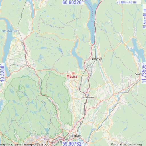
Maura GPS coordinates[2]
60° 15' 29.88" North, 11° 1' 54.912" East
| Map corner | latitude | longitude |
|---|---|---|
| Upper-left | 60.60526°, | 10.3288° |
| Center: | 60.2583°, | 11.03192° |
| Lower-right: | 59.90762°, | 11.73505° |
| Map W x H: | 77.6×77.6 km | = 48.2×48.2mi |
| max Lat: | 71.04137° ⇑57.8% North |
| Maura: | 60.2583° |
| min Lat: | ⇓42.2% South 58.0274° |
| min Long | Maura | max Long |
| 4.71485° | 11.03192° | 31.11066° |
| W 67.6%⇐ | ⇒32.4% E |
Elevation
Elevation of Maura is 200 m = 656 ft, and this is 95.8 m = 314 ft above average elevation for this country.
| Max E: |
897 m = 2943 ft | 16.5% |
| Maura | 200 m 656 ft | |
| Avg. | 104.2 m = 342 ft | |
Min E: |
1 m = 3 ft | 83.5% |
See also: Norway elevation on elevation.city.
Geographical zone
Maura is located in North temperate zone (between Tropic of Cancer and the Arctic Circle). Distance of this North polar circle is 701.1 km =435.6 mi to North.| Distance of | km | miles | from Maura |
|---|---|---|---|
| North Pole | 3307 | 2054.9 | to North |
| Arctic Circle | 701.1 | 435.6 | to North |
| Tropic Cancer | 4094.2 | 2544 | to South |
| Equator | 6700.1 | 4163.2 | to South |


Nearby cities:
15 places around Maura: (largest is in red/bold)
• Ask
20.8 km =12.9 mi,  179°
179°
• Børgen
20.8 km =12.9 mi,  151°
151°
• Eidsvoll
15.1 km =9.4 mi,  57°
57°
• Grua
20.4 km =12.7 mi,  269°
269°
• Hurdal
19.8 km =12.3 mi,  5°
5°
• Jessheim
15.2 km =9.4 mi, 148°
• Kløfta
21.3 km =13.2 mi,  164°
164°
• Neskollen
22.8 km =14.2 mi,  131°
131°
• Nordkisa
15.1 km =9.4 mi,  122°
122°
• Roa
23.2 km =14.4 mi,  278°
278°
• Rotnes
24.3 km =15.1 mi,  202°
202°
• Råholt
8.3 km =5.2 mi,  77°
77°
• Sesvoll
7.5 km =4.7 mi,  97°
97°
• Teigebyen
4.3 km =2.7 mi,  190°
190°
• Åneby
20.8 km =12.9 mi,  205°
205°
Sources, notices
• [Note1] Compared only with cities in Norway existing in our database
• [Src1] Map data: © OpenStreetMap contributors (CC-BY-SA)
• [Src2] Other city data from geonames.org with taken over terms of usage.
• [Src3] Geographical zone / Annual Mean Temperature by Robert A. Rohde @ Wikipedia
