Jessheim geodata
Jessheim (Akershus) is a seat of a second-order administrative division; located in Norway in Europe/Oslo (GMT+2) time zone. With population of 12,365 people, there are 40 cities with bigger population in this country. Compared to other cities in Norway, 60.9% of cities are located further ↑North; 71.2% of cities are located further ←West and 86.1% of cities have lower elevation than Jessheim. Note1


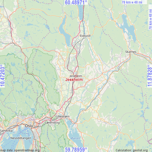
Jessheim GPS coordinates[2]
60° 8' 29.436" North, 11° 10' 30.54" East
| Map corner | latitude | longitude |
|---|---|---|
| Upper-left | 60.48971°, | 10.47203° |
| Center: | 60.14151°, | 11.17515° |
| Lower-right: | 59.78959°, | 11.87828° |
| Map W x H: | 77.8×77.8 km | = 48.3×48.3mi |
| max Lat: | 71.04137° ⇑60.9% North |
| Jessheim: | 60.14151° |
| min Lat: | ⇓39.1% South 58.0274° |
| min Long | Jessheim | max Long |
| 4.71485° | 11.17515° | 31.11066° |
| W 71.2%⇐ | ⇒28.8% E |
Elevation
Elevation of Jessheim is 212 m = 696 ft, and this is 107.8 m = 354 ft above average elevation for this country.
| Max E: |
897 m = 2943 ft | 13.9% |
| Jessheim | 212 m 696 ft | |
| Avg. | 104.2 m = 342 ft | |
Min E: |
1 m = 3 ft | 86.1% |
See also: Norway elevation on elevation.city.
Geographical zone
Jessheim is located in North temperate zone (between Tropic of Cancer and the Arctic Circle). Distance of this North polar circle is 714.1 km =443.7 mi to North.| Distance of | km | miles | from Jessheim |
|---|---|---|---|
| North Pole | 3320 | 2063 | to North |
| Arctic Circle | 714.1 | 443.7 | to North |
| Tropic Cancer | 4081.2 | 2535.9 | to South |
| Equator | 6687.1 | 4155.2 | to South |


Nearby cities:
15 places around Jessheim: (largest is in red/bold)
• Ask
11 km =6.8 mi,  224°
224°
• Auli
15.7 km =9.8 mi,  139°
139°
• Børgen
5.7 km =3.5 mi,  158°
158°
• Frogner
13.6 km =8.5 mi,  197°
197°
• Haga
14.7 km =9.1 mi,  131°
131°
• Kløfta
7.8 km =4.8 mi, 195°
• Lindeberg
11.8 km =7.3 mi,  193°
193°
• Lørenfallet
13.9 km =8.6 mi,  167°
167°
• Maura
15.2 km =9.4 mi,  328°
328°
• Neskollen
9.4 km =5.8 mi,  103°
103°
• Nordkisa
6.9 km =4.3 mi,  44°
44°
• Råholt
14.9 km =9.3 mi,  0°
0°
• Sesvoll
12.1 km =7.5 mi,  357°
357°
• Teigebyen
12.4 km =7.7 mi,  315°
315°
• Tomteråsen
11.4 km =7.1 mi,  109°
109°
Sources, notices
• [Note1] Compared only with cities in Norway existing in our database
• [Src1] Map data: © OpenStreetMap contributors (CC-BY-SA)
• [Src2] Other city data from geonames.org with taken over terms of usage.
• [Src3] Geographical zone / Annual Mean Temperature by Robert A. Rohde @ Wikipedia
