Teigebyen geodata
Teigebyen (Akershus) is a seat of a second-order administrative division; located in Norway in Europe/Oslo (GMT+2) time zone. In our database, there are 488 cities with bigger population. Compared to other cities in Norway, 59.5% of cities are located further ↑North; 67.2% of cities are located further ←West and 83.5% of cities have lower elevation than Teigebyen. Note1


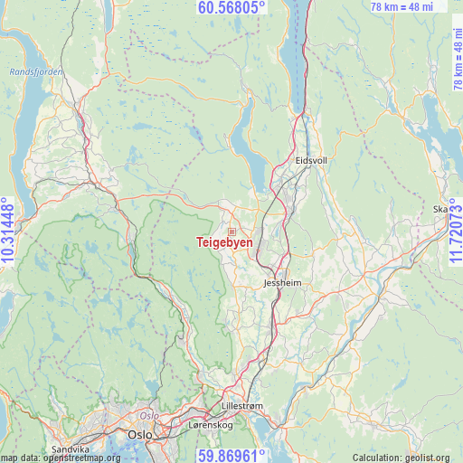
Teigebyen GPS coordinates[2]
60° 13' 14.484" North, 11° 1' 3.36" East
| Map corner | latitude | longitude |
|---|---|---|
| Upper-left | 60.56805°, | 10.31448° |
| Center: | 60.22069°, | 11.0176° |
| Lower-right: | 59.86961°, | 11.72073° |
| Map W x H: | 77.7×77.7 km | = 48.3×48.3mi |
| max Lat: | 71.04137° ⇑59.5% North |
| Teigebyen: | 60.22069° |
| min Lat: | ⇓40.5% South 58.0274° |
| min Long | Teigebyen | max Long |
| 4.71485° | 11.0176° | 31.11066° |
| W 67.2%⇐ | ⇒32.8% E |
Elevation
Elevation of Teigebyen is 200 m = 656 ft, and this is 95.8 m = 314 ft above average elevation for this country.
| Max E: |
897 m = 2943 ft | 16.5% |
| Teigebyen | 200 m 656 ft | |
| Avg. | 104.2 m = 342 ft | |
Min E: |
1 m = 3 ft | 83.5% |
See also: Norway elevation on elevation.city.
Geographical zone
Teigebyen is located in North temperate zone (between Tropic of Cancer and the Arctic Circle). Distance of this North polar circle is 705.3 km =438.3 mi to North.| Distance of | km | miles | from Teigebyen |
|---|---|---|---|
| North Pole | 3311.1 | 2057.4 | to North |
| Arctic Circle | 705.3 | 438.3 | to North |
| Tropic Cancer | 4090 | 2541.4 | to South |
| Equator | 6695.9 | 4160.6 | to South |


Nearby cities:
15 places around Teigebyen: (largest is in red/bold)
• Ask
16.6 km =10.3 mi,  176°
176°
• Børgen
17.8 km =11.1 mi,  142°
142°
• Eidsvoll
18.3 km =11.4 mi,  47°
47°
• Frogner
22.3 km =13.9 mi,  167°
167°
• Grua
20 km =12.4 mi,  281°
281°
• Jessheim
12.4 km =7.7 mi, 135°
• Kløfta
17.6 km =10.9 mi,  157°
157°
• Lindeberg
21.1 km =13.1 mi, 163°
• Maura
4.3 km =2.7 mi,  10°
10°
• Neskollen
20.9 km =13 mi,  121°
121°
• Nordkisa
14.1 km =8.8 mi,  105°
105°
• Rotnes
20.1 km =12.5 mi,  205°
205°
• Råholt
10.8 km =6.7 mi,  55°
55°
• Sesvoll
8.9 km =5.5 mi,  68°
68°
• Åneby
16.7 km =10.4 mi, 209°
Sources, notices
• [Note1] Compared only with cities in Norway existing in our database
• [Src1] Map data: © OpenStreetMap contributors (CC-BY-SA)
• [Src2] Other city data from geonames.org with taken over terms of usage.
• [Src3] Geographical zone / Annual Mean Temperature by Robert A. Rohde @ Wikipedia
