Eidsvoll geodata
Eidsvoll (Akershus) is a seat of a second-order administrative division; located in Norway in Europe/Oslo (GMT+2) time zone. In our database, there are 488 cities with bigger population. Compared to other cities in Norway, 56.5% of cities are located further ↑North; 73.6% of cities are located further ←West and 77.4% of cities have lower elevation than Eidsvoll. Note1


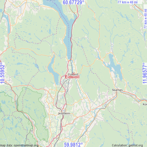
Eidsvoll GPS coordinates[2]
60° 19' 51.96" North, 11° 15' 45.504" East
| Map corner | latitude | longitude |
|---|---|---|
| Upper-left | 60.67729°, | 10.55952° |
| Center: | 60.3311°, | 11.26264° |
| Lower-right: | 59.9812°, | 11.96577° |
| Map W x H: | 77.4×77.4 km | = 48.1×48.1mi |
| max Lat: | 71.04137° ⇑56.5% North |
| Eidsvoll: | 60.3311° |
| min Lat: | ⇓43.5% South 58.0274° |
| min Long | Eidsvoll | max Long |
| 4.71485° | 11.26264° | 31.11066° |
| W 73.6%⇐ | ⇒26.4% E |
Elevation
Elevation of Eidsvoll is 160 m = 525 ft, and this is 55.8 m = 183 ft above average elevation for this country.
| Max E: |
897 m = 2943 ft | 22.6% |
| Eidsvoll | 160 m 525 ft | |
| Avg. | 104.2 m = 342 ft | |
Min E: |
1 m = 3 ft | 77.4% |
See also: Norway elevation on elevation.city.
Geographical zone
Eidsvoll is located in North temperate zone (between Tropic of Cancer and the Arctic Circle). Distance of this North polar circle is 693 km =430.6 mi to North.| Distance of | km | miles | from Eidsvoll |
|---|---|---|---|
| North Pole | 3298.9 | 2049.8 | to North |
| Arctic Circle | 693 | 430.6 | to North |
| Tropic Cancer | 4102.3 | 2549.1 | to South |
| Equator | 6708.2 | 4168.3 | to South |


Nearby cities:
15 places around Eidsvoll: (largest is in red/bold)
• Børgen
26.5 km =16.5 mi,  185°
185°
• Fjellfoten
29.2 km =18.1 mi,  156°
156°
• Hurdal
15.8 km =9.8 mi,  317°
317°
• Jessheim
21.6 km =13.4 mi, 192°
• Kløfta
29.4 km =18.3 mi, 193°
• Maura
15.1 km =9.4 mi,  237°
237°
• Neskollen
23.7 km =14.7 mi,  169°
169°
• Nordkisa
16.2 km =10.1 mi,  179°
179°
• Råholt
7.7 km =4.8 mi,  216°
216°
• Sand
16.7 km =10.4 mi,  66°
66°
• Sesvoll
10.5 km =6.5 mi,  210°
210°
• Skarnes
24.8 km =15.4 mi,  110°
110°
• Teigebyen
18.3 km =11.4 mi,  227°
227°
• Tomteråsen
25.6 km =15.9 mi, 166°
• Årnes
25.9 km =16.1 mi,  153°
153°
Sources, notices
• [Note1] Compared only with cities in Norway existing in our database
• [Src1] Map data: © OpenStreetMap contributors (CC-BY-SA)
• [Src2] Other city data from geonames.org with taken over terms of usage.
• [Src3] Geographical zone / Annual Mean Temperature by Robert A. Rohde @ Wikipedia
