Nesna geodata
Nesna (Nordland) is a seat of a second-order administrative division; located in Norway in Europe/Oslo (GMT+2) time zone. With population of 1,211 people, there are 268 cities with bigger population in this country. Compared to other cities in Norway, 85.1% of cities are located further ↓South; 84.7% of cities are located further ←West and 77.8% of cities have higher elevation than Nesna. Note1


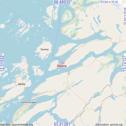
Nesna GPS coordinates[2]
66° 11' 53.412" North, 13° 1' 6.384" East
| Map corner | latitude | longitude |
|---|---|---|
| Upper-left | 66.48035°, | 12.31532° |
| Center: | 66.19817°, | 13.01844° |
| Lower-right: | 65.91281°, | 13.72157° |
| Map W x H: | 63.1×63.1 km | = 39.2×39.2mi |
| max Lat: | 71.04137° ⇑14.9% North |
| Nesna: | 66.19817° |
| min Lat: | ⇓85.1% South 58.0274° |
| min Long | Nesna | max Long |
| 4.71485° | 13.01844° | 31.11066° |
| W 84.7%⇐ | ⇒15.3% E |
Elevation
Elevation of Nesna is 12 m = 39 ft, and this is 92.2 m = 302 ft below average elevation for this country.
| Max E: |
897 m = 2943 ft | 77.8% |
| Avg. | 104.2 m = 342 ft | |
| Nesna | 12 m = 39 ft | |
Min E: |
1 m = 3 ft | 22.2% |
See also: Norway elevation on elevation.city.
Geographical zone
Nesna is located in North temperate zone (between Tropic of Cancer and the Arctic Circle). Distance of this North polar circle is 40.6 km =25.2 mi to North.| Distance of | km | miles | from Nesna |
|---|---|---|---|
| North Pole | 2646.5 | 1644.5 | to North |
| Arctic Circle | 40.6 | 25.2 | to North |
| Tropic Cancer | 4754.6 | 2954.4 | to South |
| Equator | 7360.5 | 4573.6 | to South |


Nearby cities:
15 places around Nesna: (largest is in red/bold)
• Gladstad
75.2 km =46.7 mi,  219°
219°
• Hauknes
47.9 km =29.8 mi,  78°
78°
• Hemnesberget
27 km =16.8 mi, 83°
• Husøya
53.2 km =33.1 mi,  309°
309°
• Korgen
38.6 km =24 mi,  110°
110°
• Leland
15.3 km =9.5 mi,  192°
192°
• Lurøy
25.8 km =16 mi,  342°
342°
• Mo i Rana
51.9 km =32.2 mi, 75°
• Mosjøen
41 km =25.5 mi,  169°
169°
• Sandnessjøen
26.2 km =16.3 mi, 221°
• Silvalen
40.7 km =25.3 mi,  233°
233°
• Solfjellsjøen
25.7 km =16 mi,  249°
249°
• Storforshei
71.3 km =44.3 mi,  71°
71°
• Vevelstad
61.6 km =38.3 mi,  205°
205°
• Vågaholmen
58.5 km =36.4 mi,  11°
11°
Sources, notices
• [Note1] Compared only with cities in Norway existing in our database
• [Src1] Map data: © OpenStreetMap contributors (CC-BY-SA)
• [Src2] Other city data from geonames.org with taken over terms of usage.
• [Src3] Geographical zone / Annual Mean Temperature by Robert A. Rohde @ Wikipedia
