Korgen geodata
Korgen (Nordland) is a seat of a second-order administrative division; located in Norway in Europe/Oslo (GMT+2) time zone. With population of 858 people, there are 345 cities with bigger population in this country. Compared to other cities in Norway, 84.8% of cities are located further ↓South; 87% of cities are located further ←West and 69% of cities have higher elevation than Korgen. Note1


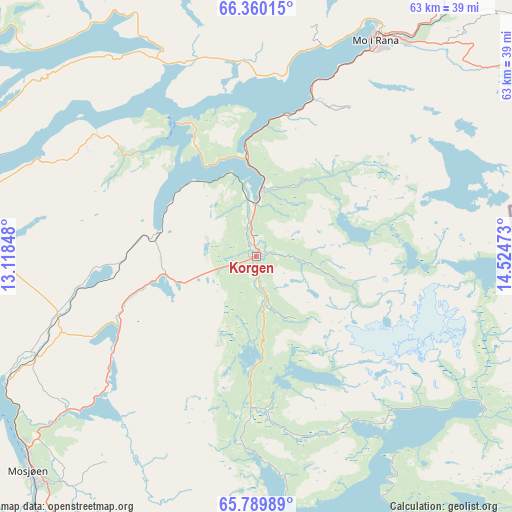
Korgen GPS coordinates[2]
66° 4' 35.832" North, 13° 49' 17.76" East
| Map corner | latitude | longitude |
|---|---|---|
| Upper-left | 66.36015°, | 13.11848° |
| Center: | 66.07662°, | 13.8216° |
| Lower-right: | 65.78989°, | 14.52473° |
| Map W x H: | 63.4×63.4 km | = 39.4×39.4mi |
| max Lat: | 71.04137° ⇑15.2% North |
| Korgen: | 66.07662° |
| min Lat: | ⇓84.8% South 58.0274° |
| min Long | Korgen | max Long |
| 4.71485° | 13.8216° | 31.11066° |
| W 87%⇐ | ⇒13% E |
Elevation
Elevation of Korgen is 20 m = 66 ft, and this is 84.2 m = 276 ft below average elevation for this country.
| Max E: |
897 m = 2943 ft | 69% |
| Avg. | 104.2 m = 342 ft | |
| Korgen | 20 m = 66 ft | |
Min E: |
1 m = 3 ft | 31% |
See also: Norway elevation on elevation.city.
Geographical zone
Korgen is located in North temperate zone (between Tropic of Cancer and the Arctic Circle). Distance of this North polar circle is 54.1 km =33.6 mi to North.| Distance of | km | miles | from Korgen |
|---|---|---|---|
| North Pole | 2660 | 1652.8 | to North |
| Arctic Circle | 54.1 | 33.6 | to North |
| Tropic Cancer | 4741.1 | 2946 | to South |
| Equator | 7347 | 4565.2 | to South |


Nearby cities:
15 places around Korgen: (largest is in red/bold)
• Hattfjelldal
53.8 km =33.4 mi,  171°
171°
• Hauknes
25.5 km =15.8 mi,  25°
25°
• Hemnesberget
18.9 km =11.7 mi,  330°
330°
• Leland
39.6 km =24.6 mi,  267°
267°
• Lurøy
58.1 km =36.1 mi,  310°
310°
• Mo i Rana
30 km =18.6 mi, 28°
• Mosjøen
39.1 km =24.3 mi,  226°
226°
• Nesna
38.6 km =24 mi,  290°
290°
• Sandnessjøen
54.1 km =33.6 mi,  263°
263°
• Silvalen
70 km =43.5 mi, 261°
• Solfjellsjøen
60.5 km =37.6 mi, 274°
• Storforshei
48.3 km =30 mi,  40°
40°
• Trofors
63.3 km =39.3 mi,  197°
197°
• Vevelstad
75.7 km =47 mi,  236°
236°
• Vågaholmen
74.7 km =46.4 mi,  341°
341°
Sources, notices
• [Note1] Compared only with cities in Norway existing in our database
• [Src1] Map data: © OpenStreetMap contributors (CC-BY-SA)
• [Src2] Other city data from geonames.org with taken over terms of usage.
• [Src3] Geographical zone / Annual Mean Temperature by Robert A. Rohde @ Wikipedia
