Rotnes geodata
Rotnes (Akershus) is a seat of a second-order administrative division; located in Norway in Europe/Oslo (GMT+2) time zone. With population of 4,705 people, there are 96 cities with bigger population in this country. Compared to other cities in Norway, 63.3% of cities are located further ↑North; 64.9% of cities are located further ←West and 82.6% of cities have lower elevation than Rotnes. Note1


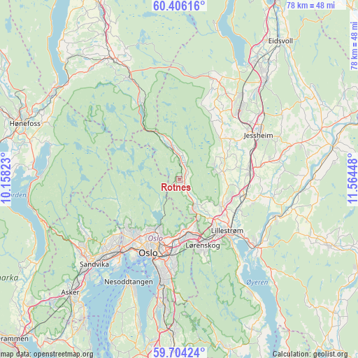
Rotnes GPS coordinates[2]
60° 3' 25.452" North, 10° 51' 40.86" East
| Map corner | latitude | longitude |
|---|---|---|
| Upper-left | 60.40616°, | 10.15823° |
| Center: | 60.05707°, | 10.86135° |
| Lower-right: | 59.70424°, | 11.56448° |
| Map W x H: | 78×78 km | = 48.5×48.5mi |
| max Lat: | 71.04137° ⇑63.3% North |
| Rotnes: | 60.05707° |
| min Lat: | ⇓36.7% South 58.0274° |
| min Long | Rotnes | max Long |
| 4.71485° | 10.86135° | 31.11066° |
| W 64.9%⇐ | ⇒35.1% E |
Elevation
Elevation of Rotnes is 190 m = 623 ft, and this is 85.8 m = 281 ft above average elevation for this country.
| Max E: |
897 m = 2943 ft | 17.4% |
| Rotnes | 190 m 623 ft | |
| Avg. | 104.2 m = 342 ft | |
Min E: |
1 m = 3 ft | 82.6% |
See also: Norway elevation on elevation.city.
Geographical zone
Rotnes is located in North temperate zone (between Tropic of Cancer and the Arctic Circle). Distance of this North polar circle is 723.5 km =449.6 mi to North.| Distance of | km | miles | from Rotnes |
|---|---|---|---|
| North Pole | 3329.3 | 2068.7 | to North |
| Arctic Circle | 723.5 | 449.6 | to North |
| Tropic Cancer | 4071.8 | 2530.1 | to South |
| Equator | 6677.7 | 4149.3 | to South |


Nearby cities:
15 places around Rotnes: (largest is in red/bold)
• Ask
9.8 km =6.1 mi,  80°
80°
• Børgen
19.9 km =12.4 mi, 78°
• Fjerdingby
18.4 km =11.4 mi,  142°
142°
• Frogner
13.9 km =8.6 mi,  105°
105°
• Jessheim
19.8 km =12.3 mi,  61°
61°
• Kjenn
14.9 km =9.3 mi,  159°
159°
• Kløfta
15.5 km =9.6 mi, 82°
• Leirsund
14.2 km =8.8 mi,  118°
118°
• Lillestrøm
15.3 km =9.5 mi, 137°
• Lindeberg
14.7 km =9.1 mi,  98°
98°
• Lysaker
20.6 km =12.8 mi,  217°
217°
• Oslo
17.3 km =10.7 mi,  201°
201°
• Sjølyststranda
18.2 km =11.3 mi,  213°
213°
• Teigebyen
20.1 km =12.5 mi,  25°
25°
• Åneby
3.6 km =2.2 mi,  7°
7°
Sources, notices
• [Note1] Compared only with cities in Norway existing in our database
• [Src1] Map data: © OpenStreetMap contributors (CC-BY-SA)
• [Src2] Other city data from geonames.org with taken over terms of usage.
• [Src3] Geographical zone / Annual Mean Temperature by Robert A. Rohde @ Wikipedia
