Hauge i Dalane geodata
Hauge i Dalane (Rogaland) is a seat of a second-order administrative division; located in Norway in Europe/Oslo (GMT+2) time zone. With population of 2,148 people, there are 186 cities with bigger population in this country. Compared to other cities in Norway, 96.2% of cities are located further ↑North; 79.7% of cities are located further →East and 58.2% of cities have higher elevation than Hauge i Dalane. Note1


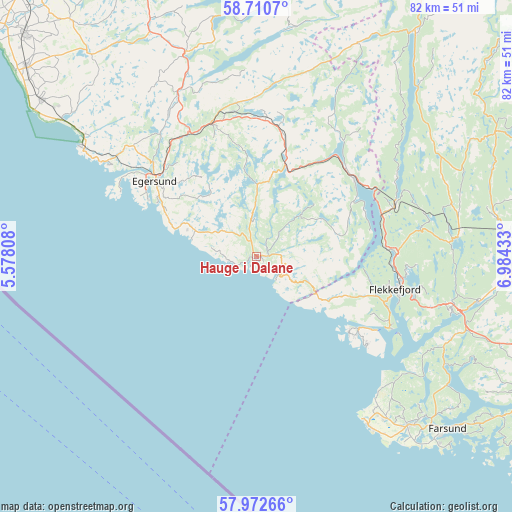
Hauge i Dalane GPS coordinates[2]
58° 20' 36.996" North, 6° 16' 52.356" East
| Map corner | latitude | longitude |
|---|---|---|
| Upper-left | 58.7107°, | 5.57808° |
| Center: | 58.34361°, | 6.28121° |
| Lower-right: | 57.97266°, | 6.98433° |
| Map W x H: | 82.1×82.1 km | = 51×51mi |
| max Lat: | 71.04137° ⇑96.2% North |
| Hauge i Dalane: | 58.34361° |
| min Lat: | ⇓3.8% South 58.0274° |
| min Long | Hauge i Dalane | max Long |
| 4.71485° | 6.28121° | 31.11066° |
| W 20.3%⇐ | ⇒79.7% E |
Elevation
Elevation of Hauge i Dalane is 30 m = 98 ft, and this is 74.2 m = 243 ft below average elevation for this country.
| Max E: |
897 m = 2943 ft | 58.2% |
| Avg. | 104.2 m = 342 ft | |
| Hauge i Dalane | 30 m = 98 ft | |
Min E: |
1 m = 3 ft | 41.8% |
See also: Norway elevation on elevation.city.
Geographical zone
Hauge i Dalane is located in North temperate zone (between Tropic of Cancer and the Arctic Circle). Distance of this North polar circle is 914 km =567.9 mi to North.| Distance of | km | miles | from Hauge i Dalane |
|---|---|---|---|
| North Pole | 3519.9 | 2187.2 | to North |
| Arctic Circle | 914 | 567.9 | to North |
| Tropic Cancer | 3881.3 | 2411.7 | to South |
| Equator | 6487.2 | 4031 | to South |


Nearby cities:
15 places around Hauge i Dalane: (largest is in red/bold)
• Egersund
20.3 km =12.6 mi,  306°
306°
• Farsund
41.3 km =25.7 mi,  132°
132°
• Flekkefjord
22.8 km =14.2 mi,  103°
103°
• Hellvik
27.8 km =17.3 mi,  302°
302°
• Liknes
39.9 km =24.8 mi, 95°
• Lyngdal
51.5 km =32 mi,  116°
116°
• Moi
20.2 km =12.6 mi,  51°
51°
• Nærbø
51.7 km =32.1 mi, 313°
• Sira
23.8 km =14.8 mi,  68°
68°
• Tonstad
43.6 km =27.1 mi,  35°
35°
• Vanse
36.4 km =22.6 mi,  138°
138°
• Varhaug
47.4 km =29.5 mi, 310°
• Vestbygd
32.5 km =20.2 mi,  146°
146°
• Vigrestad
43.1 km =26.8 mi, 305°
• Vikeså
34.5 km =21.4 mi,  341°
341°
Sources, notices
• [Note1] Compared only with cities in Norway existing in our database
• [Src1] Map data: © OpenStreetMap contributors (CC-BY-SA)
• [Src2] Other city data from geonames.org with taken over terms of usage.
• [Src3] Geographical zone / Annual Mean Temperature by Robert A. Rohde @ Wikipedia
