Egersund geodata
Egersund (Rogaland) is a seat of a second-order administrative division; located in Norway in Europe/Oslo (GMT+2) time zone. With population of 9,502 people, there are 51 cities with bigger population in this country. Compared to other cities in Norway, 95.4% of cities are located further ↑North; 83.1% of cities are located further →East and 89.4% of cities have higher elevation than Egersund. Note1


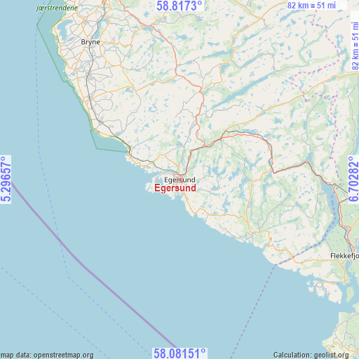
Egersund GPS coordinates[2]
58° 27' 4.788" North, 5° 59' 58.92" East
| Map corner | latitude | longitude |
|---|---|---|
| Upper-left | 58.8173°, | 5.29657° |
| Center: | 58.45133°, | 5.9997° |
| Lower-right: | 58.08151°, | 6.70282° |
| Map W x H: | 81.8×81.8 km | = 50.8×50.8mi |
| max Lat: | 71.04137° ⇑95.4% North |
| Egersund: | 58.45133° |
| min Lat: | ⇓4.6% South 58.0274° |
| min Long | Egersund | max Long |
| 4.71485° | 5.9997° | 31.11066° |
| W 16.9%⇐ | ⇒83.1% E |
Elevation
Elevation of Egersund is 4 m = 13 ft, and this is 100.2 m = 329 ft below average elevation for this country.
| Max E: |
897 m = 2943 ft | 89.4% |
| Avg. | 104.2 m = 342 ft | |
| Egersund | 4 m = 13 ft | |
Min E: |
1 m = 3 ft | 10.6% |
See also: Norway elevation on elevation.city.
Geographical zone
Egersund is located in North temperate zone (between Tropic of Cancer and the Arctic Circle). Distance of this North polar circle is 902 km =560.5 mi to North.| Distance of | km | miles | from Egersund |
|---|---|---|---|
| North Pole | 3507.9 | 2179.7 | to North |
| Arctic Circle | 902 | 560.5 | to North |
| Tropic Cancer | 3893.3 | 2419.2 | to South |
| Equator | 6499.2 | 4038.4 | to South |


Nearby cities:
15 places around Egersund: (largest is in red/bold)
• Bryne
37.6 km =23.4 mi,  327°
327°
• Flekkefjord
42.2 km =26.2 mi,  113°
113°
• Hauge i Dalane
20.3 km =12.6 mi,  126°
126°
• Hellvik
7.7 km =4.8 mi,  292°
292°
• Kleppe
41.8 km =26 mi, 329°
• Lyefjell
35.1 km =21.8 mi, 334°
• Moi
32.1 km =19.9 mi,  88°
88°
• Nærbø
31.7 km =19.7 mi,  318°
318°
• Oltedal
42 km =26.1 mi,  2°
2°
• Sandnes
47.2 km =29.3 mi,  341°
341°
• Sira
38.7 km =24 mi,  95°
95°
• Varhaug
27.2 km =16.9 mi,  312°
312°
• Vigrestad
22.8 km =14.2 mi, 305°
• Vikeså
21.4 km =13.3 mi,  14°
14°
• Ålgård
35.8 km =22.2 mi,  346°
346°
Sources, notices
• [Note1] Compared only with cities in Norway existing in our database
• [Src1] Map data: © OpenStreetMap contributors (CC-BY-SA)
• [Src2] Other city data from geonames.org with taken over terms of usage.
• [Src3] Geographical zone / Annual Mean Temperature by Robert A. Rohde @ Wikipedia
