Nærbø geodata
Nærbø (Rogaland) is a populated place; located in Norway in Europe/Oslo (GMT+2) time zone. With population of 4,975 people, there are 95 cities with bigger population in this country. Compared to other cities in Norway, 93.4% of cities are located further ↑North; 88.3% of cities are located further →East and 54.7% of cities have higher elevation than Nærbø. Note1


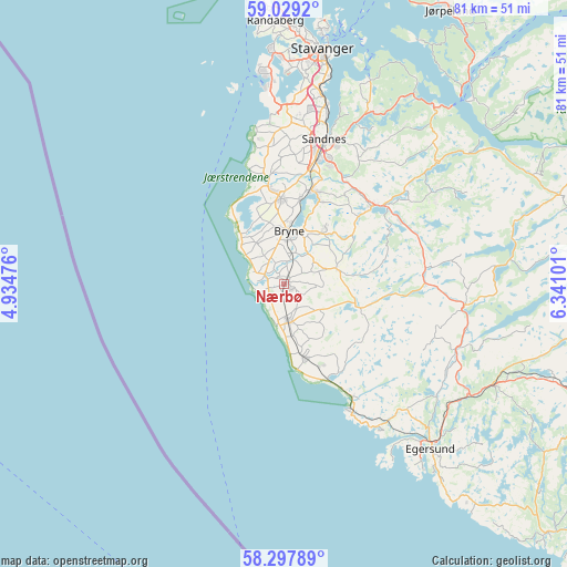
Nærbø GPS coordinates[2]
58° 39' 55.656" North, 5° 38' 16.368" East
| Map corner | latitude | longitude |
|---|---|---|
| Upper-left | 59.0292°, | 4.93476° |
| Center: | 58.66546°, | 5.63788° |
| Lower-right: | 58.29789°, | 6.34101° |
| Map W x H: | 81.3×81.3 km | = 50.5×50.5mi |
| max Lat: | 71.04137° ⇑93.4% North |
| Nærbø: | 58.66546° |
| min Lat: | ⇓6.6% South 58.0274° |
| min Long | Nærbø | max Long |
| 4.71485° | 5.63788° | 31.11066° |
| W 11.7%⇐ | ⇒88.3% E |
Elevation
Elevation of Nærbø is 35 m = 115 ft, and this is 69.2 m = 227 ft below average elevation for this country.
| Max E: |
897 m = 2943 ft | 54.7% |
| Avg. | 104.2 m = 342 ft | |
| Nærbø | 35 m = 115 ft | |
Min E: |
1 m = 3 ft | 45.3% |
See also: Norway elevation on elevation.city.
Geographical zone
Nærbø is located in North temperate zone (between Tropic of Cancer and the Arctic Circle). Distance of this North polar circle is 878.2 km =545.7 mi to North.| Distance of | km | miles | from Nærbø |
|---|---|---|---|
| North Pole | 3484.1 | 2164.9 | to North |
| Arctic Circle | 878.2 | 545.7 | to North |
| Tropic Cancer | 3917.1 | 2434 | to South |
| Equator | 6523 | 4053.2 | to South |


Nearby cities:
15 places around Nærbø: (largest is in red/bold)
• Bryne
7.8 km =4.8 mi,  4°
4°
• Egersund
31.7 km =19.7 mi,  138°
138°
• Hellvik
25.1 km =15.6 mi,  146°
146°
• Hommersåk
31.4 km =19.5 mi,  23°
23°
• Kleppe
12.1 km =7.5 mi,  357°
357°
• Lyefjell
9.6 km =6 mi,  36°
36°
• Oltedal
29.3 km =18.2 mi,  51°
51°
• Sandnes
21.5 km =13.4 mi, 15°
• Sola
24.8 km =15.4 mi, 1°
• Stavanger
34.3 km =21.3 mi,  9°
9°
• Tananger
30.3 km =18.8 mi,  353°
353°
• Varhaug
5.4 km =3.4 mi,  168°
168°
• Vigrestad
10.8 km =6.7 mi, 166°
• Vikeså
26.4 km =16.4 mi,  96°
96°
• Ålgård
16.6 km =10.3 mi, 48°
Sources, notices
• [Note1] Compared only with cities in Norway existing in our database
• [Src1] Map data: © OpenStreetMap contributors (CC-BY-SA)
• [Src2] Other city data from geonames.org with taken over terms of usage.
• [Src3] Geographical zone / Annual Mean Temperature by Robert A. Rohde @ Wikipedia
