Vikeså geodata
Vikeså (Rogaland) is a seat of a second-order administrative division; located in Norway in Europe/Oslo (GMT+2) time zone. With population of 715 people, there are 379 cities with bigger population in this country. Compared to other cities in Norway, 93.7% of cities are located further ↑North; 82% of cities are located further →East and 65.7% of cities have lower elevation than Vikeså. Note1


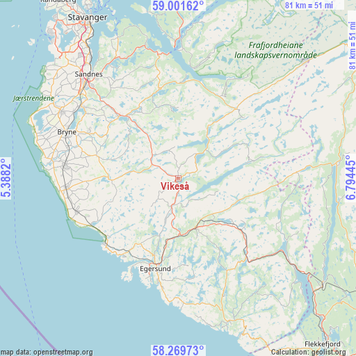
Vikeså GPS coordinates[2]
58° 38' 15.324" North, 6° 5' 28.788" East
| Map corner | latitude | longitude |
|---|---|---|
| Upper-left | 59.00162°, | 5.3882° |
| Center: | 58.63759°, | 6.09133° |
| Lower-right: | 58.26973°, | 6.79445° |
| Map W x H: | 81.4×81.4 km | = 50.6×50.6mi |
| max Lat: | 71.04137° ⇑93.7% North |
| Vikeså: | 58.63759° |
| min Lat: | ⇓6.3% South 58.0274° |
| min Long | Vikeså | max Long |
| 4.71485° | 6.09133° | 31.11066° |
| W 18%⇐ | ⇒82% E |
Elevation
Elevation of Vikeså is 97 m = 318 ft, and this is 7.2 m = 24 ft below average elevation for this country.
| Max E: |
897 m = 2943 ft | 34.3% |
| Avg. | 104.2 m = 342 ft | |
| Vikeså | 97 m = 318 ft | |
Min E: |
1 m = 3 ft | 65.7% |
See also: Norway elevation on elevation.city.
Geographical zone
Vikeså is located in North temperate zone (between Tropic of Cancer and the Arctic Circle). Distance of this North polar circle is 881.3 km =547.6 mi to North.| Distance of | km | miles | from Vikeså |
|---|---|---|---|
| North Pole | 3487.2 | 2166.8 | to North |
| Arctic Circle | 881.3 | 547.6 | to North |
| Tropic Cancer | 3914 | 2432 | to South |
| Equator | 6519.9 | 4051.3 | to South |


Nearby cities:
15 places around Vikeså: (largest is in red/bold)
• Bryne
27.8 km =17.3 mi,  292°
292°
• Egersund
21.4 km =13.3 mi,  194°
194°
• Forsand
29.6 km =18.4 mi,  1°
1°
• Hauge i Dalane
34.5 km =21.4 mi,  161°
161°
• Hellvik
21.6 km =13.4 mi,  214°
214°
• Hommersåk
34.9 km =21.7 mi,  336°
336°
• Kleppe
30.7 km =19.1 mi,  299°
299°
• Lyefjell
23.2 km =14.4 mi, 297°
• Moi
33.4 km =20.8 mi,  126°
126°
• Nærbø
26.4 km =16.4 mi,  276°
276°
• Oltedal
21.5 km =13.4 mi,  351°
351°
• Sandnes
31.5 km =19.6 mi,  319°
319°
• Varhaug
25.2 km =15.7 mi,  265°
265°
• Vigrestad
24.8 km =15.4 mi,  252°
252°
• Ålgård
19.7 km =12.2 mi, 315°
Sources, notices
• [Note1] Compared only with cities in Norway existing in our database
• [Src1] Map data: © OpenStreetMap contributors (CC-BY-SA)
• [Src2] Other city data from geonames.org with taken over terms of usage.
• [Src3] Geographical zone / Annual Mean Temperature by Robert A. Rohde @ Wikipedia
